
Col de Tamié
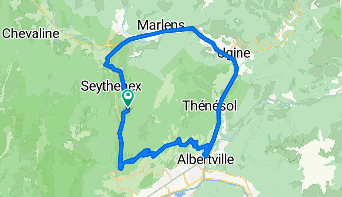
A cycling route starting in Faverges, Auvergne-Rhône-Alpes, France.
Overview
About this route
vanaf de camping in Les Combes een rondje over col de Tamié
- -:--
- Duration
- 44.4 km
- Distance
- 825 m
- Ascent
- 828 m
- Descent
- ---
- Avg. speed
- ---
- Max. altitude

Route quality
Waytypes & surfaces along the route
Waytypes
Busy road
20.9 km
(47 %)
Road
12.5 km
(28 %)
Surfaces
Paved
33.1 km
(75 %)
Unpaved
0 km
(<1 %)
Asphalt
33.1 km
(75 %)
Gravel
0 km
(<1 %)
Undefined
11.3 km
(25 %)
Continue with Bikemap
Use, edit, or download this cycling route
You would like to ride Col de Tamié or customize it for your own trip? Here is what you can do with this Bikemap route:
Free features
- Save this route as favorite or in collections
- Copy & plan your own version of this route
- Sync your route with Garmin or Wahoo
Premium features
Free trial for 3 days, or one-time payment. More about Bikemap Premium.
- Navigate this route on iOS & Android
- Export a GPX / KML file of this route
- Create your custom printout (try it for free)
- Download this route for offline navigation
Discover more Premium features.
Get Bikemap PremiumFrom our community
Other popular routes starting in Faverges
 Gravel en Bauges 2 variante sauvage
- Distance
- 80.4 km
- Ascent
- 2,942 m
- Descent
- 2,939 m
- Location
- Faverges, Auvergne-Rhône-Alpes, France
 2021-09-09 - Tag 2 - Annecy ==> Valloire
- Distance
- 130.1 km
- Ascent
- 4,259 m
- Descent
- 3,348 m
- Location
- Faverges, Auvergne-Rhône-Alpes, France
 Faverges/HauteSavoie'05, 2.Etappe: Marais + Croix-Fry + Aravis + Arpettaz
- Distance
- 91.9 km
- Ascent
- 2,216 m
- Descent
- 2,220 m
- Location
- Faverges, Auvergne-Rhône-Alpes, France
 Faverges/HauteSavoie'05, 1.Etappe: Leschaux + Frêne + Tamié
- Distance
- 102.1 km
- Ascent
- 1,574 m
- Descent
- 1,575 m
- Location
- Faverges, Auvergne-Rhône-Alpes, France
 Tour 2016 - Col du Tamie, 99 km/1650 m
- Distance
- 98.9 km
- Ascent
- 1,489 m
- Descent
- 1,490 m
- Location
- Faverges, Auvergne-Rhône-Alpes, France
 Tour 01: Östlich vom Lac d'Annecy
- Distance
- 92.5 km
- Ascent
- 2,014 m
- Descent
- 2,005 m
- Location
- Faverges, Auvergne-Rhône-Alpes, France
 J2 - Etape du Tour - Col des Près + Cormet
- Distance
- 139.1 km
- Ascent
- 4,860 m
- Descent
- 4,861 m
- Location
- Faverges, Auvergne-Rhône-Alpes, France
 Gravel en Bauges 2
- Distance
- 82.5 km
- Ascent
- 2,646 m
- Descent
- 2,643 m
- Location
- Faverges, Auvergne-Rhône-Alpes, France
Open it in the app