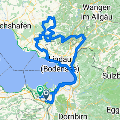
20160804_173222.gpx
A cycling route starting in Sankt Margrethen, Canton of St. Gallen, Switzerland.
Overview
About this route
TEASI track
- -:--
- Duration
- 38.1 km
- Distance
- 14 m
- Ascent
- 16 m
- Descent
- ---
- Avg. speed
- ---
- Avg. speed
Route quality
Waytypes & surfaces along the route
Waytypes
Quiet road
11.9 km
(31 %)
Cycleway
11.1 km
(29 %)
Surfaces
Paved
34.5 km
(90 %)
Unpaved
3.1 km
(8 %)
Asphalt
34.2 km
(90 %)
Loose gravel
1.7 km
(4 %)
Route highlights
Points of interest along the route
Point of interest after 24.8 km
11 | 12 Gallusstrasse
Continue with Bikemap
Use, edit, or download this cycling route
You would like to ride 20160804_173222.gpx or customize it for your own trip? Here is what you can do with this Bikemap route:
Free features
- Save this route as favorite or in collections
- Copy & plan your own version of this route
- Sync your route with Garmin or Wahoo
Premium features
Free trial for 3 days, or one-time payment. More about Bikemap Premium.
- Navigate this route on iOS & Android
- Export a GPX / KML file of this route
- Create your custom printout (try it for free)
- Download this route for offline navigation
Discover more Premium features.
Get Bikemap PremiumFrom our community
Other popular routes starting in Sankt Margrethen
- 2013 St. Margerethen-Zagreb
- Distance
- 876.8 km
- Ascent
- 7,042 m
- Descent
- 7,085 m
- Location
- Sankt Margrethen, Canton of St. Gallen, Switzerland
- Höchst-Konstanz (3)
- Distance
- 53.1 km
- Ascent
- 57 m
- Descent
- 56 m
- Location
- Sankt Margrethen, Canton of St. Gallen, Switzerland
- 4-Tages-Passfahrt Vorarlberg-Italien-Graubünden
- Distance
- 330.4 km
- Ascent
- 4,568 m
- Descent
- 4,447 m
- Location
- Sankt Margrethen, Canton of St. Gallen, Switzerland
- St.Anton
- Distance
- 38.3 km
- Ascent
- 852 m
- Descent
- 849 m
- Location
- Sankt Margrethen, Canton of St. Gallen, Switzerland
- SchweizMobil 4: Alpenpanorama-Route
- Distance
- 480 km
- Ascent
- 8,734 m
- Descent
- 8,732 m
- Location
- Sankt Margrethen, Canton of St. Gallen, Switzerland
- Alpenpanorama- Route Nr. 4
- Distance
- 478.9 km
- Ascent
- 12,216 m
- Descent
- 12,212 m
- Location
- Sankt Margrethen, Canton of St. Gallen, Switzerland
- Bodensee-Comer See
- Distance
- 315.6 km
- Ascent
- 2,560 m
- Descent
- 2,523 m
- Location
- Sankt Margrethen, Canton of St. Gallen, Switzerland
- Bodensee harmadik nap megtett út
- Distance
- 60.3 km
- Ascent
- 40 m
- Descent
- 42 m
- Location
- Sankt Margrethen, Canton of St. Gallen, Switzerland
Open it in the app