

45 Km Old orchard 2016
A cycling route starting in Old Orchard Beach, State of Maine, United States.
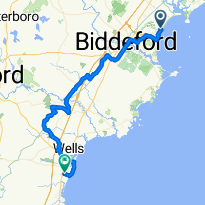
Overview
About this route
Jusqua l'ile du coté sud
- -:--
- Duration
- 44.4 km
- Distance
- 121 m
- Ascent
- 107 m
- Descent
- ---
- Avg. speed
- ---
- Max. altitude
Route photos

Route quality
Waytypes & surfaces along the route
Waytypes
Quiet road
15.5 km
(35 %)
Road
4 km
(9 %)
Surfaces
Paved
12.9 km
(29 %)
Asphalt
12.4 km
(28 %)
Paved (undefined)
0.4 km
(1 %)
Undefined
31.5 km
(71 %)
Route highlights
Points of interest along the route

Point of interest after 44.4 km
old Orchard 45km
Continue with Bikemap
Use, edit, or download this cycling route
You would like to ride 45 Km Old orchard 2016 or customize it for your own trip? Here is what you can do with this Bikemap route:
Free features
- Save this route as favorite or in collections
- Copy & plan your own version of this route
- Sync your route with Garmin or Wahoo
Premium features
Free trial for 3 days, or one-time payment. More about Bikemap Premium.
- Navigate this route on iOS & Android
- Export a GPX / KML file of this route
- Create your custom printout (try it for free)
- Download this route for offline navigation
Discover more Premium features.
Get Bikemap PremiumFrom our community
Other popular routes starting in Old Orchard Beach
 Maine 70.3
- Distance
- 89.2 km
- Ascent
- 246 m
- Descent
- 246 m
- Location
- Old Orchard Beach, State of Maine, United States
 6 Fourth St, Biddeford to 132 Mills Rd, Kennebunkport
- Distance
- 12.7 km
- Ascent
- 0 m
- Descent
- 6 m
- Location
- Old Orchard Beach, State of Maine, United States
 Portland rte
- Distance
- 23.3 km
- Ascent
- 145 m
- Descent
- 132 m
- Location
- Old Orchard Beach, State of Maine, United States
 Short bike tour through Old Orchard Beach
- Distance
- 2 km
- Ascent
- 36 m
- Descent
- 34 m
- Location
- Old Orchard Beach, State of Maine, United States
 ogunquit sunday 25 August
- Distance
- 52.8 km
- Ascent
- 336 m
- Descent
- 331 m
- Location
- Old Orchard Beach, State of Maine, United States
 Recovered Route
- Distance
- 27 km
- Ascent
- 0 m
- Descent
- 3 m
- Location
- Old Orchard Beach, State of Maine, United States
 playing hookie!
- Distance
- 23.7 km
- Ascent
- 387 m
- Descent
- 387 m
- Location
- Old Orchard Beach, State of Maine, United States
 70.2 Maine
- Distance
- 90.2 km
- Ascent
- 206 m
- Descent
- 206 m
- Location
- Old Orchard Beach, State of Maine, United States
Open it in the app