

Vorschlag Tag 7
A cycling route starting in Stadl an der Mur, Styria, Austria.
Overview
About this route
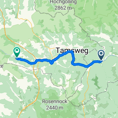
Tamsweg - Obertauern - Radstadt - Annaberg - Bad Goisern
- -:--
- Duration
- 129.2 km
- Distance
- 1,436 m
- Ascent
- 1,856 m
- Descent
- ---
- Avg. speed
- ---
- Max. altitude

Route quality
Waytypes & surfaces along the route
Waytypes
Quiet road
41.4 km
(32 %)
Track
11.6 km
(9 %)
Surfaces
Paved
99.5 km
(77 %)
Unpaved
10.3 km
(8 %)
Asphalt
89.2 km
(69 %)
Paved (undefined)
10.3 km
(8 %)
Continue with Bikemap
Use, edit, or download this cycling route
You would like to ride Vorschlag Tag 7 or customize it for your own trip? Here is what you can do with this Bikemap route:
Free features
- Save this route as favorite or in collections
- Copy & plan your own version of this route
- Split it into stages to create a multi-day tour
- Sync your route with Garmin or Wahoo
Premium features
Free trial for 3 days, or one-time payment. More about Bikemap Premium.
- Navigate this route on iOS & Android
- Export a GPX / KML file of this route
- Create your custom printout (try it for free)
- Download this route for offline navigation
Discover more Premium features.
Get Bikemap PremiumFrom our community
Other popular routes starting in Stadl an der Mur
 Vorschlag Tag 7
- Distance
- 129.2 km
- Ascent
- 1,436 m
- Descent
- 1,856 m
- Location
- Stadl an der Mur, Styria, Austria
 Oesterreich 2016 - 4/7
- Distance
- 133.2 km
- Ascent
- 4,072 m
- Descent
- 4,139 m
- Location
- Stadl an der Mur, Styria, Austria
 Mur 14: Stadl an der Mur - Hintermuhr, 50,8km, 362hm
- Distance
- 50.8 km
- Ascent
- 362 m
- Descent
- 99 m
- Location
- Stadl an der Mur, Styria, Austria
 Stadl an der Mur - Flattnitz - Stadl an der Mur 40km
- Distance
- 43.9 km
- Ascent
- 948 m
- Descent
- 947 m
- Location
- Stadl an der Mur, Styria, Austria
 Mura 22 1.Dan
- Distance
- 66.3 km
- Ascent
- 782 m
- Descent
- 901 m
- Location
- Stadl an der Mur, Styria, Austria
 Route nach Villach
- Distance
- 84.9 km
- Ascent
- 1,755 m
- Descent
- 2,658 m
- Location
- Stadl an der Mur, Styria, Austria
 Drau Mur Runde 18
- Distance
- 33.2 km
- Ascent
- 236 m
- Descent
- 79 m
- Location
- Stadl an der Mur, Styria, Austria
 Stadl an der Mur, Stadl-Predlitz nach Vordermuhr, Muhr
- Distance
- 51.4 km
- Ascent
- 585 m
- Descent
- 351 m
- Location
- Stadl an der Mur, Styria, Austria
Open it in the app