

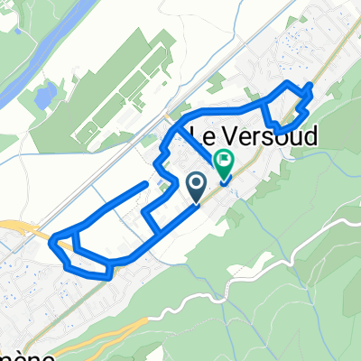
Dimanche14
A cycling route starting in Le Versoud, Auvergne-Rhône-Alpes, France.
Overview
About this route
- -:--
- Duration
- 134.3 km
- Distance
- 2,741 m
- Ascent
- 2,741 m
- Descent
- ---
- Avg. speed
- ---
- Max. altitude
Route quality
Waytypes & surfaces along the route
Waytypes
Quiet road
20.1 km
(15 %)
Road
14.8 km
(11 %)
Surfaces
Paved
83.3 km
(62 %)
Unpaved
1.3 km
(1 %)
Asphalt
83.3 km
(62 %)
Unpaved (undefined)
1.3 km
(1 %)
Undefined
49.7 km
(37 %)
Continue with Bikemap
Use, edit, or download this cycling route
You would like to ride Dimanche14 or customize it for your own trip? Here is what you can do with this Bikemap route:
Free features
- Save this route as favorite or in collections
- Copy & plan your own version of this route
- Split it into stages to create a multi-day tour
- Sync your route with Garmin or Wahoo
Premium features
Free trial for 3 days, or one-time payment. More about Bikemap Premium.
- Navigate this route on iOS & Android
- Export a GPX / KML file of this route
- Create your custom printout (try it for free)
- Download this route for offline navigation
Discover more Premium features.
Get Bikemap PremiumFrom our community
Other popular routes starting in Le Versoud
 test
test- Distance
- 79.6 km
- Ascent
- 1,389 m
- Descent
- 1,376 m
- Location
- Le Versoud, Auvergne-Rhône-Alpes, France
 De Rue de la Tour à Rue de la Tour
- Distance
- 8.7 km
- Ascent
- 39 m
- Descent
- 98 m
- Location
- Le Versoud, Auvergne-Rhône-Alpes, France
 domene_porte_cucheron_granier
- Distance
- 97.4 km
- Ascent
- 1,953 m
- Descent
- 1,952 m
- Location
- Le Versoud, Auvergne-Rhône-Alpes, France
 Les 3 massifs
- Distance
- 112 km
- Ascent
- 2,211 m
- Descent
- 2,211 m
- Location
- Le Versoud, Auvergne-Rhône-Alpes, France
 Grenoble-Morzine 2
- Distance
- 245.2 km
- Ascent
- 4,243 m
- Descent
- 3,479 m
- Location
- Le Versoud, Auvergne-Rhône-Alpes, France
 De Route de Lancey, Saint-Ismier à Place de l'Emendra 69, Crolles
- Distance
- 9.9 km
- Ascent
- 110 m
- Descent
- 149 m
- Location
- Le Versoud, Auvergne-Rhône-Alpes, France
 hurtières, prapoutel puis balcons
- Distance
- 66.3 km
- Ascent
- 1,455 m
- Descent
- 1,455 m
- Location
- Le Versoud, Auvergne-Rhône-Alpes, France
 Le Versoud - Combeloup - Le Versoud
- Distance
- 32.3 km
- Ascent
- 804 m
- Descent
- 802 m
- Location
- Le Versoud, Auvergne-Rhône-Alpes, France
Open it in the app