
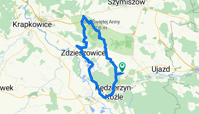
WyprawaNaWulkan - KedzierzynKozle-GoraSwAnny
A cycling route starting in Kędzierzyn-Koźle, Opole Voivodeship, Poland.
Overview
About this route
- -:--
- Duration
- 52.4 km
- Distance
- 275 m
- Ascent
- 275 m
- Descent
- ---
- Avg. speed
- ---
- Max. altitude

Route quality
Waytypes & surfaces along the route
Waytypes
Road
20.4 km
(39 %)
Track
13.6 km
(26 %)
Surfaces
Paved
24.6 km
(47 %)
Unpaved
11 km
(21 %)
Asphalt
24.6 km
(47 %)
Ground
8.9 km
(17 %)
Route highlights
Points of interest along the route
Point of interest after 12.5 km
Amfiteatr
Point of interest after 12.8 km
Klasztor Franciszkanów
Point of interest after 18.6 km
Wapiennik - Gniewosz Plamisty
Point of interest after 23.8 km
Pałac w Zyrowej
Point of interest after 29.1 km
Pizzeria
Point of interest after 31.9 km
Kosciół ala Romański
Continue with Bikemap
Use, edit, or download this cycling route
You would like to ride WyprawaNaWulkan - KedzierzynKozle-GoraSwAnny or customize it for your own trip? Here is what you can do with this Bikemap route:
Free features
- Save this route as favorite or in collections
- Copy & plan your own version of this route
- Sync your route with Garmin or Wahoo
Premium features
Free trial for 3 days, or one-time payment. More about Bikemap Premium.
- Navigate this route on iOS & Android
- Export a GPX / KML file of this route
- Create your custom printout (try it for free)
- Download this route for offline navigation
Discover more Premium features.
Get Bikemap PremiumFrom our community
Other popular routes starting in Kędzierzyn-Koźle
 Rozruchowa - Laki Kozielskie
- Distance
- 24.5 km
- Ascent
- 60 m
- Descent
- 61 m
- Location
- Kędzierzyn-Koźle, Opole Voivodeship, Poland
 Kentucky-Jarnoltowek
- Distance
- 74 km
- Ascent
- 469 m
- Descent
- 281 m
- Location
- Kędzierzyn-Koźle, Opole Voivodeship, Poland
 Piotra Skargi 23, Kędzierzyn-Koźle do Piotra Skargi 23, Kędzierzyn-Koźle
- Distance
- 48.1 km
- Ascent
- 411 m
- Descent
- 448 m
- Location
- Kędzierzyn-Koźle, Opole Voivodeship, Poland
 Kędzierzyn-Koźle do Kochanowskiego 25, Gliwice
- Distance
- 109.2 km
- Ascent
- 952 m
- Descent
- 904 m
- Location
- Kędzierzyn-Koźle, Opole Voivodeship, Poland
 WyprawaNaWulkan - KedzierzynKozle-GoraSwAnny
- Distance
- 52.4 km
- Ascent
- 275 m
- Descent
- 275 m
- Location
- Kędzierzyn-Koźle, Opole Voivodeship, Poland
 Kentucky-Gr. Sw. Anny (Asfalt)
- Distance
- 47.2 km
- Ascent
- 275 m
- Descent
- 278 m
- Location
- Kędzierzyn-Koźle, Opole Voivodeship, Poland
 Kentucky-Lesnica
- Distance
- 34 km
- Ascent
- 75 m
- Descent
- 77 m
- Location
- Kędzierzyn-Koźle, Opole Voivodeship, Poland
![[GPS] Góra św Anny - wariacja [01]](https://media.bikemap.net/routes/159491/staticmaps/in_c980e6c3-0b50-4a90-a227-5860c500d8f2_400x400_bikemap-2021-3D-static.png) [GPS] Góra św Anny - wariacja [01]
[GPS] Góra św Anny - wariacja [01]- Distance
- 42.1 km
- Ascent
- 478 m
- Descent
- 476 m
- Location
- Kędzierzyn-Koźle, Opole Voivodeship, Poland
Open it in the app