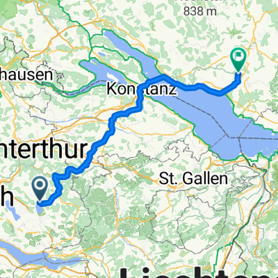
Pfäffikon-Zürich-Brugg-Gelterkinden
A cycling route starting in Pfäffikon / Pfäffikon (Dorfkern), Canton of Zurich, Switzerland.
Overview
About this route
Bikeroute von Pfäffikon via Zürich, Brugg, Bözberg (559müM), Frick, Rothenfluh (650müM), Gelterkinden
84 km mit ca 890 Höhenmeter
- -:--
- Duration
- 83.7 km
- Distance
- 697 m
- Ascent
- 787 m
- Descent
- ---
- Avg. speed
- 580 m
- Avg. speed
Route quality
Waytypes & surfaces along the route
Waytypes
Busy road
32 km
(38 %)
Road
16.1 km
(19 %)
Surfaces
Paved
79 km
(94 %)
Unpaved
1.5 km
(2 %)
Asphalt
77.5 km
(93 %)
Gravel
1.1 km
(1 %)
Continue with Bikemap
Use, edit, or download this cycling route
You would like to ride Pfäffikon-Zürich-Brugg-Gelterkinden or customize it for your own trip? Here is what you can do with this Bikemap route:
Free features
- Save this route as favorite or in collections
- Copy & plan your own version of this route
- Sync your route with Garmin or Wahoo
Premium features
Free trial for 3 days, or one-time payment. More about Bikemap Premium.
- Navigate this route on iOS & Android
- Export a GPX / KML file of this route
- Create your custom printout (try it for free)
- Download this route for offline navigation
Discover more Premium features.
Get Bikemap PremiumFrom our community
Other popular routes starting in Pfäffikon / Pfäffikon (Dorfkern)
- Pfäffikon-Zürich-Brugg-Gelterkinden
- Distance
- 83.7 km
- Ascent
- 697 m
- Descent
- 787 m
- Location
- Pfäffikon / Pfäffikon (Dorfkern), Canton of Zurich, Switzerland
- leotwo. Pfäffikon, Saland, Turbenthal, Wildberg, Pfäffikon
- Distance
- 25.1 km
- Ascent
- 355 m
- Descent
- 296 m
- Location
- Pfäffikon / Pfäffikon (Dorfkern), Canton of Zurich, Switzerland
- Pfäffikon Rund um Zürichsee
- Distance
- 76.9 km
- Ascent
- 335 m
- Descent
- 408 m
- Location
- Pfäffikon / Pfäffikon (Dorfkern), Canton of Zurich, Switzerland
- Rund um Pfäffikon
- Distance
- 31.8 km
- Ascent
- 885 m
- Descent
- 883 m
- Location
- Pfäffikon / Pfäffikon (Dorfkern), Canton of Zurich, Switzerland
- Egger Route Extended
- Distance
- 70.4 km
- Ascent
- 599 m
- Descent
- 599 m
- Location
- Pfäffikon / Pfäffikon (Dorfkern), Canton of Zurich, Switzerland
- Pfäffikon-Sternenberg-Bauma-Wildberg-Hittnau-Pfäffikon
- Distance
- 54.9 km
- Ascent
- 1,174 m
- Descent
- 1,104 m
- Location
- Pfäffikon / Pfäffikon (Dorfkern), Canton of Zurich, Switzerland
- Ostblockvelotour 2008
- Distance
- 8,234.1 km
- Ascent
- 5,108 m
- Descent
- 5,108 m
- Location
- Pfäffikon / Pfäffikon (Dorfkern), Canton of Zurich, Switzerland
- Pfäffikon - Gossa ZH PLANUNG
- Distance
- 13.5 km
- Ascent
- 107 m
- Descent
- 189 m
- Location
- Pfäffikon / Pfäffikon (Dorfkern), Canton of Zurich, Switzerland
Open it in the app