

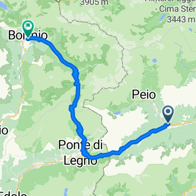
Pejo - La strada militare
A cycling route starting in Ossana, Trentino-Alto Adige, Italy.
Overview
About this route
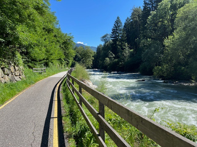
A scenic itinerary immersed in the Stelvio National Park. It winds through the narrow Val del Monte from the village of Peio Fonti along an Austrian military road dating back to the 1914-1918 war, where remains of military fortifications called 'stoi' recently restored are visible. The route then continues around the dam, the artificial basin of Pian Palù, with a stop at the famous oligomineral springs.
- -:--
- Duration
- 38.3 km
- Distance
- 1,037 m
- Ascent
- 1,038 m
- Descent
- ---
- Avg. speed
- ---
- Max. altitude
Route quality
Waytypes & surfaces along the route
Waytypes
Track
11.5 km
(30 %)
Path
6.1 km
(16 %)
Surfaces
Paved
16.8 km
(44 %)
Unpaved
3.4 km
(9 %)
Asphalt
16.5 km
(43 %)
Gravel
2.3 km
(6 %)
Continue with Bikemap
Use, edit, or download this cycling route
You would like to ride Pejo - La strada militare or customize it for your own trip? Here is what you can do with this Bikemap route:
Free features
- Save this route as favorite or in collections
- Copy & plan your own version of this route
- Sync your route with Garmin or Wahoo
Premium features
Free trial for 3 days, or one-time payment. More about Bikemap Premium.
- Navigate this route on iOS & Android
- Export a GPX / KML file of this route
- Create your custom printout (try it for free)
- Download this route for offline navigation
Discover more Premium features.
Get Bikemap PremiumFrom our community
Other popular routes starting in Ossana
 Ossana- Caldes a-r
- Distance
- 43.4 km
- Ascent
- 382 m
- Descent
- 361 m
- Location
- Ossana, Trentino-Alto Adige, Italy
 Val di Sole Ossana - Caldes A-R
- Distance
- 44.7 km
- Ascent
- 402 m
- Descent
- 401 m
- Location
- Ossana, Trentino-Alto Adige, Italy
 Val di Sole Ossana - Caldes
- Distance
- 41.7 km
- Ascent
- 385 m
- Descent
- 389 m
- Location
- Ossana, Trentino-Alto Adige, Italy
 Ossana - Tonalle - Gavia - Bormio
- Distance
- 67.2 km
- Ascent
- 2,268 m
- Descent
- 2,024 m
- Location
- Ossana, Trentino-Alto Adige, Italy
 Pejo - La strada militare
- Distance
- 38.3 km
- Ascent
- 1,037 m
- Descent
- 1,038 m
- Location
- Ossana, Trentino-Alto Adige, Italy
 Val di Sole - Ossana Caldes
- Distance
- 42.8 km
- Ascent
- 387 m
- Descent
- 388 m
- Location
- Ossana, Trentino-Alto Adige, Italy
 TOUR DEL MONTOZZO
- Distance
- 59.6 km
- Ascent
- 2,005 m
- Descent
- 2,004 m
- Location
- Ossana, Trentino-Alto Adige, Italy
 Alpencross 2010 | Etappe 7
- Distance
- 67.3 km
- Ascent
- 2,594 m
- Descent
- 3,001 m
- Location
- Ossana, Trentino-Alto Adige, Italy
Open it in the app