

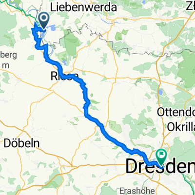
16.07.25 Staritz-Elster/Elbe
A cycling route starting in Mühlberg, Brandenburg, Germany.
Overview
About this route
von
https://www.bikemap.net/de/route/3728649-160724-klotzsche-staritz/
Teilweise wg. Umleitungen (Deicherhöhung) auf Radwegen neben der Hauptstraße, für 2016 ist die rechte Flußseite derzeit nicht besonders zu empfehlen.
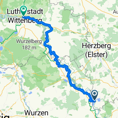
nach
https://www.bikemap.net/de/route/3734805-160726-elster-dessau-sud/
- -:--
- Duration
- 86.5 km
- Distance
- 55 m
- Ascent
- 73 m
- Descent
- ---
- Avg. speed
- ---
- Max. altitude

Route quality
Waytypes & surfaces along the route
Waytypes
Track
32.1 km
(37 %)
Quiet road
27 km
(31 %)
Surfaces
Paved
74.3 km
(86 %)
Unpaved
0.9 km
(1 %)
Asphalt
65.3 km
(75 %)
Paved (undefined)
6.8 km
(8 %)
Route highlights
Points of interest along the route
Point of interest after 22.1 km
Trinkpause an der Wasserbar beim Wasserwerk.

Photo after 27.1 km
Blick von der Elbe aut Torgau.
Point of interest after 28.9 km
Postamt

Photo after 30 km
Kaffeepause am Stadtplatz.
Point of interest after 66.6 km
Gutes Bauernhofeis.!
Point of interest after 86.2 km
Kleines Lokal mit kl. Biergarten.
Continue with Bikemap
Use, edit, or download this cycling route
You would like to ride 16.07.25 Staritz-Elster/Elbe or customize it for your own trip? Here is what you can do with this Bikemap route:
Free features
- Save this route as favorite or in collections
- Copy & plan your own version of this route
- Split it into stages to create a multi-day tour
- Sync your route with Garmin or Wahoo
Premium features
Free trial for 3 days, or one-time payment. More about Bikemap Premium.
- Navigate this route on iOS & Android
- Export a GPX / KML file of this route
- Create your custom printout (try it for free)
- Download this route for offline navigation
Discover more Premium features.
Get Bikemap PremiumFrom our community
Other popular routes starting in Mühlberg
 Tag5_Mühlberg-Dresden
- Distance
- 79.3 km
- Ascent
- 302 m
- Descent
- 285 m
- Location
- Mühlberg, Brandenburg, Germany
 ZARM 2024 6. Tag
- Distance
- 89.2 km
- Ascent
- 174 m
- Descent
- 191 m
- Location
- Mühlberg, Brandenburg, Germany
 Mühlberg-Dresden 310519
- Distance
- 67.6 km
- Ascent
- 58 m
- Descent
- 34 m
- Location
- Mühlberg, Brandenburg, Germany
 Dröschkau 12, Belgern-Schildau nach Öfw 42 - Altstadt II, Dresden
- Distance
- 85.7 km
- Ascent
- 552 m
- Descent
- 529 m
- Location
- Mühlberg, Brandenburg, Germany
 2024_Elberadweg_Etappe2
- Distance
- 63.4 km
- Ascent
- 158 m
- Descent
- 174 m
- Location
- Mühlberg, Brandenburg, Germany
 2. ET Mühlberg-Wittenberg
- Distance
- 100 km
- Ascent
- 130 m
- Descent
- 153 m
- Location
- Mühlberg, Brandenburg, Germany
 Mühlberg/Elbe-Dommitzsch
- Distance
- 52.1 km
- Ascent
- 67 m
- Descent
- 67 m
- Location
- Mühlberg, Brandenburg, Germany
 Mühlberg-Torgau-zurück
- Distance
- 56.1 km
- Ascent
- 47 m
- Descent
- 46 m
- Location
- Mühlberg, Brandenburg, Germany
Open it in the app