Lochlip Road, Lochwinnoch to 78A South Beach, Troon
- 41.4 km
- 196 m
- 226 m
- Lochwinnoch, Scotland, United Kingdom
A cycling route starting in Lochwinnoch, Scotland, United Kingdom.
Overview
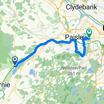
Lochwinnoch to Paisley
This 24th section of St Ninian’s Way follows a signposted footpath and National Cycle Route 7 all the way to Paisley. The starting point is the footpath beside Castle Semple Loch which proceeds to a bridge over a motorway (6 km). Then continue north along Black Cart Water to another bridge (2 km). Cross bridge and continue along track to Elderslie (1.5km), and then on to Sauce Hill, just south of Paisley (3 km). Then take the Causeyside Road 200 m and turn right onto Gordon Street for 100 m and over the River Clyde, onto Cotton Street to Paisley Abbey (300m). An option is to continue on to Gauze Street and to the crossroads with St Mirren’s Catholic Cathedral.
Scenic and signposted footpath
Also part of the Whithorn Way - http://www.whithornway.org . courtesy of the WWSG where a detailed route description with grid references is available.
For a map overview of Part 1 and Part 2 of St Ninian’s Way please go to https://www.bikemap.net/en/route/3548129-st-ninians-way-carlisle-to-st-andrews-part-1-carlisle-to-whithorn/
St Ninian’s Way is one of the great pilgrim routes in Scotland to St Andrews - The Way of St Andrews - For other routes see http://www.thewayofstandrews.com
created this 9 years ago
Route quality
Cycleway
14.5 km
91 %
Road
0.2 km
1 %
Paved
15.3 km
(96 %)
Asphalt
15.3 km
96 %
Undefined
0.6 km
4 %
Route highlights
St Mirin's Cathedral
Paisley Abbey
Continue with Bikemap
You would like to ride St Ninian's Way - Lochwinnoch to Paisley or customize it for your own trip? Here is what you can do with this Bikemap route:
Free trial for 3 days, or one-time payment. More about Bikemap Premium.
Discover more Premium features.
Get Bikemap PremiumFrom our community
Open it in the app