

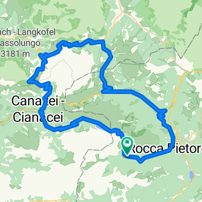
malga ciapela-forca rossa-val contrin-fedaia
A cycling route starting in Rocca Pietore, Veneto, Italy.
Overview
About this route
Percorso tecnico e esclusivamente escursionistico in quota per presenza di ghiaioni e balze rocciose di notevole pendenza; ottimo punti di appoggio per camping tra passo fedaia e malga ciapela. In Val Contrin malga omonima che vende i propri prodotti lattiero caseari e verdi prati dove trovare riposo.
- -:--
- Duration
- 34.2 km
- Distance
- 2,048 m
- Ascent
- 2,046 m
- Descent
- ---
- Avg. speed
- ---
- Max. altitude
Route highlights
Points of interest along the route
Accommodation after 0.9 km
camping
Accommodation after 5.2 km
Rifugio Falier
Photo after 7.2 km
Forca Rossa, punto panoramico
Photo after 9.2 km
le Saline, punto panoramico
Accommodation after 9.3 km
Rifugio Fuciade
Point of interest after 9.7 km
fuori pista su traccia di sentiero tra crode e pietraie
Photo after 10.9 km
La Tascia, punto panoramico
Point of interest after 12 km
ripido ghiaione discosceso
Photo after 12.4 km
Passo delle Cirele
Point of interest after 12.6 km
canaloni e balze rocciose
Point of interest after 13.6 km
Passo Ombretola
Point of interest after 13.7 km
Passo Ombreta
Accommodation after 15.7 km
Malga Contrin, vendita e self service di ottimi prodotti tipici
Accommodation after 16 km
Rifugio Contrin
Accommodation after 17.2 km
Rifugio malga Cianci
Point of interest after 20.7 km
centro abitato di Penìa - Canazei; possibile collegamento di trasporto pubblico
Point of interest after 20.7 km
percorso naturalistico e didattico, 4 km ciclabili
Point of interest after 25.3 km
via crucis
Photo after 27.5 km
Piani di Fedaia, punto panoramico
Point of interest after 28 km
impianti di risalita Marmolada
Point of interest after 28 km
museo della Guerra
Point of interest after 30.3 km
passo Fedaia
Point of interest after 32.4 km
impianti di risalita per Arabba
Continue with Bikemap
Use, edit, or download this cycling route
You would like to ride malga ciapela-forca rossa-val contrin-fedaia or customize it for your own trip? Here is what you can do with this Bikemap route:
Free features
- Save this route as favorite or in collections
- Copy & plan your own version of this route
- Sync your route with Garmin or Wahoo
Premium features
Free trial for 3 days, or one-time payment. More about Bikemap Premium.
- Navigate this route on iOS & Android
- Export a GPX / KML file of this route
- Create your custom printout (try it for free)
- Download this route for offline navigation
Discover more Premium features.
Get Bikemap PremiumFrom our community
Other popular routes starting in Rocca Pietore
 Caprile -TRE CIME DI LAVAREDO
- Distance
- 111.2 km
- Ascent
- 3,281 m
- Descent
- 3,275 m
- Location
- Rocca Pietore, Veneto, Italy
 Giro d`Italia 2008 - stage 4
- Distance
- 85.5 km
- Ascent
- 3,088 m
- Descent
- 2,747 m
- Location
- Rocca Pietore, Veneto, Italy
 Caprile rifugio auronzo
- Distance
- 120.9 km
- Ascent
- 3,314 m
- Descent
- 3,314 m
- Location
- Rocca Pietore, Veneto, Italy
 lidl-tour-2015-1-6
- Distance
- 87.9 km
- Ascent
- 1,462 m
- Descent
- 2,345 m
- Location
- Rocca Pietore, Veneto, Italy
 Caprile to Caprile
- Distance
- 99.5 km
- Ascent
- 2,538 m
- Descent
- 2,536 m
- Location
- Rocca Pietore, Veneto, Italy
 Dolomites - etapa 4
- Distance
- 98 km
- Ascent
- 2,757 m
- Descent
- 2,744 m
- Location
- Rocca Pietore, Veneto, Italy
 Dolomiti 3. dan
- Distance
- 89.1 km
- Ascent
- 1,999 m
- Descent
- 1,999 m
- Location
- Rocca Pietore, Veneto, Italy
 Giro d`Italia 2009 - Stage 3
- Distance
- 88 km
- Ascent
- 2,323 m
- Descent
- 1,936 m
- Location
- Rocca Pietore, Veneto, Italy
Open it in the app