

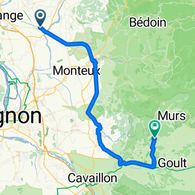
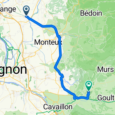
Sarrians-Gordes-Sarrians
A cycling route starting in Jonquières, Provence-Alpes-Côte d'Azur Region, France.
Overview
About this route
From Permes-les-Fontaines, L'Isle-sur-la-Sorgue to Gordes (about 45 km), return via Venasque, Carpentras; about 86 km, 750 m elevation gain
- -:--
- Duration
- 85.7 km
- Distance
- 773 m
- Ascent
- 776 m
- Descent
- ---
- Avg. speed
- ---
- Max. altitude
Route quality
Waytypes & surfaces along the route
Waytypes
Road
33.4 km
(39 %)
Quiet road
12.9 km
(15 %)
Surfaces
Paved
54 km
(63 %)
Unpaved
0.9 km
(1 %)
Asphalt
54 km
(63 %)
Ground
0.9 km
(1 %)
Undefined
30.9 km
(36 %)
Continue with Bikemap
Use, edit, or download this cycling route
You would like to ride Sarrians-Gordes-Sarrians or customize it for your own trip? Here is what you can do with this Bikemap route:
Free features
- Save this route as favorite or in collections
- Copy & plan your own version of this route
- Split it into stages to create a multi-day tour
- Sync your route with Garmin or Wahoo
Premium features
Free trial for 3 days, or one-time payment. More about Bikemap Premium.
- Navigate this route on iOS & Android
- Export a GPX / KML file of this route
- Create your custom printout (try it for free)
- Download this route for offline navigation
Discover more Premium features.
Get Bikemap PremiumFrom our community
Other popular routes starting in Jonquières
 La Roque Alric, Aubignan Mardi 01.04.14
- Distance
- 55.2 km
- Ascent
- 362 m
- Descent
- 361 m
- Location
- Jonquières, Provence-Alpes-Côte d'Azur Region, France
 Les Sablons - Avignon
- Distance
- 37.5 km
- Ascent
- 135 m
- Descent
- 179 m
- Location
- Jonquières, Provence-Alpes-Côte d'Azur Region, France
 Jonquières - Gordes
- Distance
- 55.8 km
- Ascent
- 425 m
- Descent
- 150 m
- Location
- Jonquières, Provence-Alpes-Côte d'Azur Region, France
 Jonquières - Gordes
- Distance
- 48.8 km
- Ascent
- 215 m
- Descent
- 120 m
- Location
- Jonquières, Provence-Alpes-Côte d'Azur Region, France
 Villedieu, le col du Débat Vendredi 28.03.14
- Distance
- 58.8 km
- Ascent
- 338 m
- Descent
- 339 m
- Location
- Jonquières, Provence-Alpes-Côte d'Azur Region, France
 Pont du Gard
- Distance
- 95.7 km
- Ascent
- 443 m
- Descent
- 443 m
- Location
- Jonquières, Provence-Alpes-Côte d'Azur Region, France
 Tour à la con autour de jonquières
- Distance
- 17.5 km
- Ascent
- 40 m
- Descent
- 43 m
- Location
- Jonquières, Provence-Alpes-Côte d'Azur Region, France
 FX et Gérard le 08/10/13
- Distance
- 38 km
- Ascent
- 104 m
- Descent
- 105 m
- Location
- Jonquières, Provence-Alpes-Côte d'Azur Region, France
Open it in the app