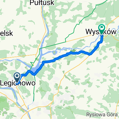
Polskiej Organizacji Wojskowej, Legionowo do Polskiej Organizacji Wojskowej, Legionowo
- 29.1 km
- 22 m
- 15 m
- Legionowo, Masovian Voivodeship, Poland
A cycling route starting in Legionowo, Masovian Voivodeship, Poland.
Overview
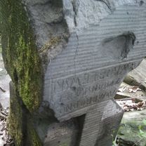
Trasa w mieście po drogach rowerowych. W lesie drogi lekko utwardzone ale i sypkie (miejscami trzeba zejść z roweru). W lesie stare opustoszałe i ograbione cmentarzysko. Trudno nawet odczytać do kogo należały groby. Uwaga na nieokryte grobowce, można wpaść lub doznać kontuzji. Nad jeziorkiem przejemnie, choć brzeg okrutnie zarośnięty.
created this 9 years ago


Route quality
Quiet road
6.4 km
(25 %)
Path
5.7 km
(22 %)
Paved
11.3 km
(44 %)
Unpaved
6.4 km
(25 %)
Asphalt
10.1 km
(39 %)
Unpaved (undefined)
2.8 km
(11 %)
Route highlights

Widok na Kwietniówkę

Cmentarzysko
Continue with Bikemap
You would like to ride To "Kwietniówka" lake route or customize it for your own trip? Here is what you can do with this Bikemap route:
Free trial for 3 days, or one-time payment. More about Bikemap Premium.
Discover more Premium features.
Get Bikemap PremiumFrom our community
Open it in the app