Nyugat-Alpok hágótúra
A cycling route starting in Zürich (Kreis 2) / Wollishofen, Canton of Zurich, Switzerland.
Overview
About this route
Hágótúra a svájci, a francia és az olasz Alpokban, 2016. június 16. – július 2. (1589 km (más mérés szerint: 1649 km), Zürich – Andermatt – Airolo – Martigny – Chamonix-Mont-Blanc – Flumet – Ugine – Annecy – Genf – Bonneville – Flumet – Ugine – Albertville – Saint-Jean-de-Maurienne – Briançon – Jausiers – Barcelonette – Jausiers – Cuneo – Pinerolo – Usseaux – Susa – Bourg-Saint-Maurice – Aosta – Martigny)
- -:--
- Duration
- 1,607.4 km
- Distance
- 16,286 m
- Ascent
- 16,258 m
- Descent
- ---
- Avg. speed
- ---
- Avg. speed
Route quality
Waytypes & surfaces along the route
Waytypes
Undefined
1,607.4 km
(100 %)
Surfaces
Undefined
1,607.4 km
(100 %)
Continue with Bikemap
Use, edit, or download this cycling route
You would like to ride Nyugat-Alpok hágótúra or customize it for your own trip? Here is what you can do with this Bikemap route:
Free features
- Save this route as favorite or in collections
- Copy & plan your own version of this route
- Sync your route with Garmin or Wahoo
Premium features
Free trial for 3 days, or one-time payment. More about Bikemap Premium.
- Navigate this route on iOS & Android
- Export a GPX / KML file of this route
- Create your custom printout (try it for free)
- Download this route for offline navigation
Discover more Premium features.
Get Bikemap PremiumFrom our community
Other popular routes starting in Zürich (Kreis 2) / Wollishofen
- Route zu Zürich Wollishofen
- Distance
- 91.2 km
- Ascent
- 2,296 m
- Descent
- 2,295 m
- Location
- Zürich (Kreis 2) / Wollishofen, Canton of Zurich, Switzerland
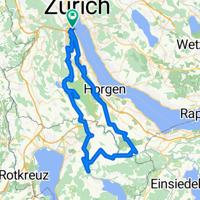
- Ironman Zürich Runde
- Distance
- 176.9 km
- Ascent
- 790 m
- Descent
- 790 m
- Location
- Zürich (Kreis 2) / Wollishofen, Canton of Zurich, Switzerland
- Zürich (Wollishofen)-Horgen-Menzingen-Hausen-Zürich
- Distance
- 70.3 km
- Ascent
- 1,058 m
- Descent
- 1,070 m
- Location
- Zürich (Kreis 2) / Wollishofen, Canton of Zurich, Switzerland
- Wollishofen-Albis-Baar-Ägeri-Sattel-Schindellegi-Hirzel-Wollishofen
- Distance
- 90.2 km
- Ascent
- 1,412 m
- Descent
- 1,412 m
- Location
- Zürich (Kreis 2) / Wollishofen, Canton of Zurich, Switzerland
- Ironman Zurich Switzerland
- Distance
- 90.2 km
- Ascent
- 537 m
- Descent
- 535 m
- Location
- Zürich (Kreis 2) / Wollishofen, Canton of Zurich, Switzerland
- Zürich-Schwägalp-Appenzell
- Distance
- 102.8 km
- Ascent
- 1,154 m
- Descent
- 837 m
- Location
- Zürich (Kreis 2) / Wollishofen, Canton of Zurich, Switzerland
- Zurich 5150 1 Lap
- Distance
- 13.2 km
- Ascent
- 88 m
- Descent
- 86 m
- Location
- Zürich (Kreis 2) / Wollishofen, Canton of Zurich, Switzerland
- Uetliberg-Runde
- Distance
- 18.1 km
- Ascent
- 587 m
- Descent
- 592 m
- Location
- Zürich (Kreis 2) / Wollishofen, Canton of Zurich, Switzerland