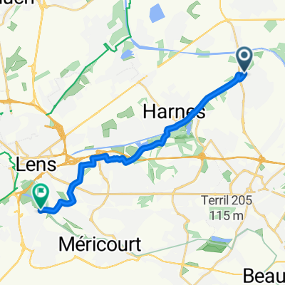
test
A cycling route starting in Courrières, Hauts-de-France, France.
Overview
About this route
- -:--
- Duration
- 18 km
- Distance
- 34 m
- Ascent
- 42 m
- Descent
- ---
- Avg. speed
- ---
- Max. altitude
Route quality
Waytypes & surfaces along the route
Waytypes
Road
10.9 km
(61 %)
Path
2.9 km
(16 %)
Surfaces
Paved
3.7 km
(21 %)
Unpaved
0.9 km
(5 %)
Asphalt
2.8 km
(16 %)
Gravel
0.9 km
(5 %)
Continue with Bikemap
Use, edit, or download this cycling route
You would like to ride test or customize it for your own trip? Here is what you can do with this Bikemap route:
Free features
- Save this route as favorite or in collections
- Copy & plan your own version of this route
- Sync your route with Garmin or Wahoo
Premium features
Free trial for 3 days, or one-time payment. More about Bikemap Premium.
- Navigate this route on iOS & Android
- Export a GPX / KML file of this route
- Create your custom printout (try it for free)
- Download this route for offline navigation
Discover more Premium features.
Get Bikemap PremiumFrom our community
Other popular routes starting in Courrières
- De Rue Emile Basly 22B, Courrières à Rue Blanchart 13, Lens
- Distance
- 12.5 km
- Ascent
- 61 m
- Descent
- 40 m
- Location
- Courrières, Hauts-de-France, France
- test
- Distance
- 18 km
- Ascent
- 34 m
- Descent
- 42 m
- Location
- Courrières, Hauts-de-France, France
- De Rue Emile Basly 15, Courrières à Rue Robespierre 4, Grenay
- Distance
- 19.3 km
- Ascent
- 90 m
- Descent
- 59 m
- Location
- Courrières, Hauts-de-France, France
- Itinéraire à partir de 4 Chemin de Douai, Courrières
- Distance
- 9.9 km
- Ascent
- 98 m
- Descent
- 97 m
- Location
- Courrières, Hauts-de-France, France
- 15 Avenue des Saules, Courrières à 2 Rue Jean Mermoz, Vendin-le-Vieil
- Distance
- 12.1 km
- Ascent
- 52 m
- Descent
- 29 m
- Location
- Courrières, Hauts-de-France, France
- De Chemin du Halage 5, Oignies à Rue du Château 1, Noyelles-Godault
- Distance
- 9.2 km
- Ascent
- 67 m
- Descent
- 66 m
- Location
- Courrières, Hauts-de-France, France
- retour harnes
- Distance
- 14.9 km
- Ascent
- 72 m
- Descent
- 69 m
- Location
- Courrières, Hauts-de-France, France
- De Rue des Capucines à Rue François Lefebvre
- Distance
- 12.1 km
- Ascent
- 48 m
- Descent
- 47 m
- Location
- Courrières, Hauts-de-France, France
Open it in the app