
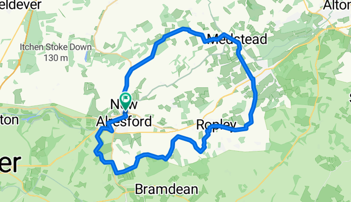
Alresford - Medstead - Ropley
A cycling route starting in Four Marks, England, United Kingdom.
Overview
About this route
- -:--
- Duration
- 35.2 km
- Distance
- 241 m
- Ascent
- 244 m
- Descent
- ---
- Avg. speed
- ---
- Max. altitude

Route quality
Waytypes & surfaces along the route
Waytypes
Quiet road
23.2 km
(66 %)
Road
7.7 km
(22 %)
Surfaces
Paved
34.8 km
(99 %)
Asphalt
34.8 km
(99 %)
Undefined
0.4 km
(1 %)
Continue with Bikemap
Use, edit, or download this cycling route
You would like to ride Alresford - Medstead - Ropley or customize it for your own trip? Here is what you can do with this Bikemap route:
Free features
- Save this route as favorite or in collections
- Copy & plan your own version of this route
- Sync your route with Garmin or Wahoo
Premium features
Free trial for 3 days, or one-time payment. More about Bikemap Premium.
- Navigate this route on iOS & Android
- Export a GPX / KML file of this route
- Create your custom printout (try it for free)
- Download this route for offline navigation
Discover more Premium features.
Get Bikemap PremiumFrom our community
Other popular routes starting in Four Marks
 50m South Loop
- Distance
- 79.6 km
- Ascent
- 602 m
- Descent
- 601 m
- Location
- Four Marks, England, United Kingdom
 MTB Lasham 28mi
- Distance
- 44.7 km
- Ascent
- 336 m
- Descent
- 337 m
- Location
- Four Marks, England, United Kingdom
 oxdrove way
- Distance
- 39 km
- Ascent
- 308 m
- Descent
- 309 m
- Location
- Four Marks, England, United Kingdom
 MTB Loop 24mi
- Distance
- 38.2 km
- Ascent
- 364 m
- Descent
- 365 m
- Location
- Four Marks, England, United Kingdom
 Itchen Abbas circuit
- Distance
- 32.9 km
- Ascent
- 460 m
- Descent
- 461 m
- Location
- Four Marks, England, United Kingdom
 Alresford loop 70 mile version
- Distance
- 110.7 km
- Ascent
- 877 m
- Descent
- 877 m
- Location
- Four Marks, England, United Kingdom
 36m Ropley Loop
- Distance
- 58.8 km
- Ascent
- 424 m
- Descent
- 424 m
- Location
- Four Marks, England, United Kingdom
 Kimber House, Lyeway Lane, Alresford to 1–5 Lower Church Lane, Farnham
- Distance
- 35.4 km
- Ascent
- 541 m
- Descent
- 613 m
- Location
- Four Marks, England, United Kingdom
Open it in the app