

DAS NATURSCHUTZGEBIET MONDRAGÓ (Mallorca)
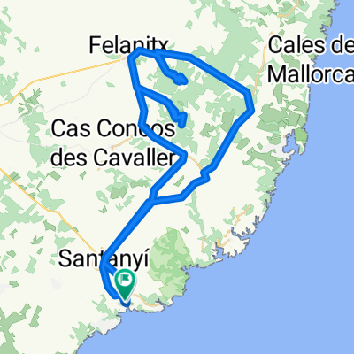
A cycling route starting in Santanyí, Balearic Islands, Spain.
Overview
About this route
Tagestour mit dem Fahrrad auf Süd-Mallorca, die Naturerlebnis und Geschichte kombiniert.
Bilder, Beshcreibungen der Sehenswürdigkeiten auf Deutsch, interaktive Karte und Routendetails: Klicken Sie bitte hier
- -:--
- Duration
- 17 km
- Distance
- 114 m
- Ascent
- 116 m
- Descent
- ---
- Avg. speed
- 60 m
- Max. altitude

Route quality
Waytypes & surfaces along the route
Waytypes
Quiet road
7 km
(41 %)
Busy road
4.8 km
(28 %)
Surfaces
Paved
6 km
(35 %)
Unpaved
1.1 km
(6 %)
Asphalt
5.7 km
(33 %)
Gravel
1.1 km
(6 %)
Continue with Bikemap
Use, edit, or download this cycling route
You would like to ride DAS NATURSCHUTZGEBIET MONDRAGÓ (Mallorca) or customize it for your own trip? Here is what you can do with this Bikemap route:
Free features
- Save this route as favorite or in collections
- Copy & plan your own version of this route
- Sync your route with Garmin or Wahoo
Premium features
Free trial for 3 days, or one-time payment. More about Bikemap Premium.
- Navigate this route on iOS & Android
- Export a GPX / KML file of this route
- Create your custom printout (try it for free)
- Download this route for offline navigation
Discover more Premium features.
Get Bikemap PremiumFrom our community
Other popular routes starting in Santanyí
 Cala Santanyi SES SALINES SAN JORDI
- Distance
- 44.9 km
- Ascent
- 485 m
- Descent
- 333 m
- Location
- Santanyí, Balearic Islands, Spain
 Cala Santanyi-Cas Concos-Alqueria Blanca-Cala Santanyi
- Distance
- 37.5 km
- Ascent
- 187 m
- Descent
- 186 m
- Location
- Santanyí, Balearic Islands, Spain
 Ruta des Sud
- Distance
- 35 km
- Ascent
- 140 m
- Descent
- 142 m
- Location
- Santanyí, Balearic Islands, Spain
 Santanyí-Biniali-Algaida-Llucmajor-Santanyí
- Distance
- 106.4 km
- Ascent
- 410 m
- Descent
- 426 m
- Location
- Santanyí, Balearic Islands, Spain
 Santanyi_ueber_zwei_Berge
- Distance
- 67.4 km
- Ascent
- 1,038 m
- Descent
- 965 m
- Location
- Santanyí, Balearic Islands, Spain
 11.03 Campos Sa sorda
- Distance
- 54.6 km
- Ascent
- 243 m
- Descent
- 241 m
- Location
- Santanyí, Balearic Islands, Spain
 FELANITX-PORRERES-VILAFRANCA-ELS CALDERERS-PINA-CAMI MUNTANYA-SON MARRANO-SES SALINES
- Distance
- 102.4 km
- Ascent
- 419 m
- Descent
- 418 m
- Location
- Santanyí, Balearic Islands, Spain
 Santanyi 2010
- Distance
- 57.8 km
- Ascent
- 623 m
- Descent
- 623 m
- Location
- Santanyí, Balearic Islands, Spain
Open it in the app