

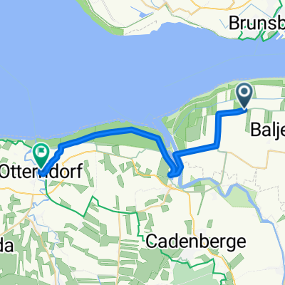
Hardy´s Elbradweg 2015 Etappe 1.2 Balje(Leuchtturm)-Schönwarth
A cycling route starting in Balje, Lower Saxony, Germany.
Overview
About this route
- -:--
- Duration
- 16.2 km
- Distance
- 0 m
- Ascent
- 0 m
- Descent
- ---
- Avg. speed
- ---
- Max. altitude

Route photos
-Schönwarth\"")
-Schönwarth\"")
-Schönwarth\"")
-Schönwarth\"")
-Schönwarth\"")
-Schönwarth\"")
-Schönwarth\"")
-Schönwarth\"")
Route quality
Waytypes & surfaces along the route
Waytypes
Track
16.2 km
(100 %)
Surfaces
Paved
15.9 km
(98 %)
Concrete
14.5 km
(89 %)
Asphalt
1.5 km
(9 %)
Undefined
0.3 km
(2 %)
Continue with Bikemap
Use, edit, or download this cycling route
You would like to ride Hardy´s Elbradweg 2015 Etappe 1.2 Balje(Leuchtturm)-Schönwarth or customize it for your own trip? Here is what you can do with this Bikemap route:
Free features
- Save this route as favorite or in collections
- Copy & plan your own version of this route
- Sync your route with Garmin or Wahoo
Premium features
Free trial for 3 days, or one-time payment. More about Bikemap Premium.
- Navigate this route on iOS & Android
- Export a GPX / KML file of this route
- Create your custom printout (try it for free)
- Download this route for offline navigation
Discover more Premium features.
Get Bikemap PremiumFrom our community
Other popular routes starting in Balje
 Hardy´s Elbradweg 2015 Etappe 1.2 Balje(Leuchtturm)-Schönwarth
- Distance
- 16.2 km
- Ascent
- 0 m
- Descent
- 0 m
- Location
- Balje, Lower Saxony, Germany
 Rückfahrt nach Wischhafen
- Distance
- 18.4 km
- Ascent
- 0 m
- Descent
- 0 m
- Location
- Balje, Lower Saxony, Germany
 Kehdinger Land CLONED FROM ROUTE 998610
- Distance
- 75.5 km
- Ascent
- 9 m
- Descent
- 8 m
- Location
- Balje, Lower Saxony, Germany
 Balje - Otterndorf
- Distance
- 21.8 km
- Ascent
- 0 m
- Descent
- 0 m
- Location
- Balje, Lower Saxony, Germany
 Balje_Cuxhaven_zurück_78km
- Distance
- 77.5 km
- Ascent
- 0 m
- Descent
- 0 m
- Location
- Balje, Lower Saxony, Germany
 Balje
Balje- Distance
- 15.5 km
- Ascent
- 0 m
- Descent
- 0 m
- Location
- Balje, Lower Saxony, Germany
 Glückstadt
- Distance
- 57.5 km
- Ascent
- 0 m
- Descent
- 0 m
- Location
- Balje, Lower Saxony, Germany
 Aufnahme vom 10.08.2016, 17:41
- Distance
- 36.6 km
- Ascent
- 0 m
- Descent
- 0 m
- Location
- Balje, Lower Saxony, Germany
Open it in the app