

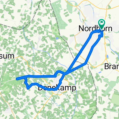
NOH-Grenz- Dinkel-Lage, Frenzwegen-NOH
A cycling route starting in Nordhorn, Lower Saxony, Germany.
Overview
About this route
Grenzübergang Parkplatz rechts, dann längs der Hauptstr, Denekamp, nach ca. 1 Km rechts Lübberdingsweg zum Kloster St.Nicolaas, weiter Richtung Lattop bis zur Dinkel, an dieser bis nach Lage, durch den Busch zum Schmuggelpfad, links zum Kloster Frenswegen, an der Dinkel zuück nach Nordhorn zum Vechtesee, am Almelookanal zuück zu Startpunkt..
- -:--
- Duration
- 34 km
- Distance
- 30 m
- Ascent
- 26 m
- Descent
- ---
- Avg. speed
- ---
- Max. altitude
Route quality
Waytypes & surfaces along the route
Waytypes
Track
9.5 km
(28 %)
Quiet road
9.4 km
(28 %)
Surfaces
Paved
20.3 km
(60 %)
Unpaved
10.1 km
(30 %)
Asphalt
11.8 km
(35 %)
Ground
3.9 km
(12 %)
Continue with Bikemap
Use, edit, or download this cycling route
You would like to ride NOH-Grenz- Dinkel-Lage, Frenzwegen-NOH or customize it for your own trip? Here is what you can do with this Bikemap route:
Free features
- Save this route as favorite or in collections
- Copy & plan your own version of this route
- Sync your route with Garmin or Wahoo
Premium features
Free trial for 3 days, or one-time payment. More about Bikemap Premium.
- Navigate this route on iOS & Android
- Export a GPX / KML file of this route
- Create your custom printout (try it for free)
- Download this route for offline navigation
Discover more Premium features.
Get Bikemap PremiumFrom our community
Other popular routes starting in Nordhorn
 Nordhorner Offroad
- Distance
- 43 km
- Ascent
- 25 m
- Descent
- 25 m
- Location
- Nordhorn, Lower Saxony, Germany
 Nordhorn - Bookholt - Stadtflur - Klausheide - Flugplatz- Vechtesee
- Distance
- 30.4 km
- Ascent
- 29 m
- Descent
- 27 m
- Location
- Nordhorn, Lower Saxony, Germany
 Nordhorn-Bad Bentheim
- Distance
- 77.9 km
- Ascent
- 302 m
- Descent
- 304 m
- Location
- Nordhorn, Lower Saxony, Germany
 Neubürgerroute 1
- Distance
- 17.9 km
- Ascent
- 22 m
- Descent
- 22 m
- Location
- Nordhorn, Lower Saxony, Germany
 Vechtetalroute bis Uelsen, dann Ootmarsum und am Almelo Kanal zurück
- Distance
- 58.9 km
- Ascent
- 401 m
- Descent
- 449 m
- Location
- Nordhorn, Lower Saxony, Germany
 Riverside-Denekamp-Hunebrug-Riverside
- Distance
- 29.2 km
- Ascent
- 49 m
- Descent
- 46 m
- Location
- Nordhorn, Lower Saxony, Germany
 20170623_091808.gpx
- Distance
- 27.1 km
- Ascent
- 28 m
- Descent
- 26 m
- Location
- Nordhorn, Lower Saxony, Germany
 20170623_091808.gpx
- Distance
- 27.1 km
- Ascent
- 44 m
- Descent
- 43 m
- Location
- Nordhorn, Lower Saxony, Germany
Open it in the app