

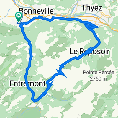
Col de Sur Cou and Col des Chasseurs
A cycling route starting in Amancy, Auvergne-Rhône-Alpes, France.
Overview
About this route
Steep and beautiful. Unpaved above 1000 metres. Trails above 1400 metres.
- -:--
- Duration
- 35.4 km
- Distance
- 1,211 m
- Ascent
- 1,211 m
- Descent
- ---
- Avg. speed
- ---
- Max. altitude

Route highlights
Points of interest along the route
Point of interest after 15.1 km
Col des Chasseurs - 1490 metres
Point of interest after 17.8 km
Col du Sur Cou - 1605 metres
Point of interest after 18.2 km
Col du Petit Cou - 1570 metres
Continue with Bikemap
Use, edit, or download this cycling route
You would like to ride Col de Sur Cou and Col des Chasseurs or customize it for your own trip? Here is what you can do with this Bikemap route:
Free features
- Save this route as favorite or in collections
- Copy & plan your own version of this route
- Sync your route with Garmin or Wahoo
Premium features
Free trial for 3 days, or one-time payment. More about Bikemap Premium.
- Navigate this route on iOS & Android
- Export a GPX / KML file of this route
- Create your custom printout (try it for free)
- Download this route for offline navigation
Discover more Premium features.
Get Bikemap PremiumFrom our community
Other popular routes starting in Amancy
 436–504 Avenue de la République, Saint-Pierre-en-Faucigny à 54 Place de l'Église, Saint-Pierre-en-Faucigny
- Distance
- 64.6 km
- Ascent
- 1,638 m
- Descent
- 1,642 m
- Location
- Amancy, Auvergne-Rhône-Alpes, France
 Jérôme26200_Tour_Haute_Savoie
- Distance
- 127.9 km
- Ascent
- 2,097 m
- Descent
- 2,097 m
- Location
- Amancy, Auvergne-Rhône-Alpes, France
 col des aravis
- Distance
- 104.9 km
- Ascent
- 1,252 m
- Descent
- 1,252 m
- Location
- Amancy, Auvergne-Rhône-Alpes, France
 Col de Sur Cou and Col des Chasseurs
- Distance
- 35.4 km
- Ascent
- 1,211 m
- Descent
- 1,211 m
- Location
- Amancy, Auvergne-Rhône-Alpes, France
 De 210 Rue de Bourre, Saint-Laurent à 524 Route des Vignes, Poisy
- Distance
- 37.9 km
- Ascent
- 620 m
- Descent
- 834 m
- Location
- Amancy, Auvergne-Rhône-Alpes, France
 St Pierre en faucigny - Col de la Colombière
- Distance
- 32.1 km
- Ascent
- 1,246 m
- Descent
- 104 m
- Location
- Amancy, Auvergne-Rhône-Alpes, France
 Avenue du Mont Blanc, Saint-Pierre-en-Faucigny à Avenue du Mont Blanc, Saint-Pierre-en-Faucigny
- Distance
- 0.8 km
- Ascent
- 3 m
- Descent
- 0 m
- Location
- Amancy, Auvergne-Rhône-Alpes, France
 Col de La Colombière - Col des Aravis
- Distance
- 84.6 km
- Ascent
- 1,855 m
- Descent
- 1,852 m
- Location
- Amancy, Auvergne-Rhône-Alpes, France
Open it in the app