
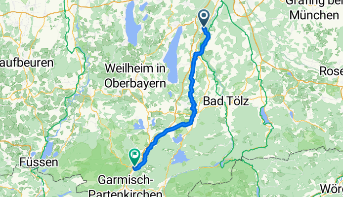
Wolfratshausen - Oberau
A cycling route starting in Schäftlarn, Bavaria, Germany.
Overview
About this route
- -:--
- Duration
- 73.1 km
- Distance
- 228 m
- Ascent
- 233 m
- Descent
- ---
- Avg. speed
- ---
- Max. altitude
Route quality
Waytypes & surfaces along the route
Waytypes
Quiet road
22.7 km
(31 %)
Track
20.9 km
(29 %)
Surfaces
Paved
52.2 km
(71 %)
Unpaved
19.6 km
(27 %)
Asphalt
51 km
(70 %)
Gravel
13.8 km
(19 %)
Continue with Bikemap
Use, edit, or download this cycling route
You would like to ride Wolfratshausen - Oberau or customize it for your own trip? Here is what you can do with this Bikemap route:
Free features
- Save this route as favorite or in collections
- Copy & plan your own version of this route
- Sync your route with Garmin or Wahoo
Premium features
Free trial for 3 days, or one-time payment. More about Bikemap Premium.
- Navigate this route on iOS & Android
- Export a GPX / KML file of this route
- Create your custom printout (try it for free)
- Download this route for offline navigation
Discover more Premium features.
Get Bikemap PremiumFrom our community
Other popular routes starting in Schäftlarn
 Hohenschäftlarn Peretshofen
- Distance
- 42 km
- Ascent
- 482 m
- Descent
- 565 m
- Location
- Schäftlarn, Bavaria, Germany
 Königsdorfer Alm - Kloster Schäftlarn
- Distance
- 64.5 km
- Ascent
- 682 m
- Descent
- 521 m
- Location
- Schäftlarn, Bavaria, Germany
 Gemütliche Route in Starnberg
- Distance
- 19.4 km
- Ascent
- 431 m
- Descent
- 362 m
- Location
- Schäftlarn, Bavaria, Germany
 Schäftlarnrunde 90-120min
- Distance
- 48.5 km
- Ascent
- 314 m
- Descent
- 324 m
- Location
- Schäftlarn, Bavaria, Germany
 Route V02.1 Tag 24 / Ende
- Distance
- 30.6 km
- Ascent
- 135 m
- Descent
- 164 m
- Location
- Schäftlarn, Bavaria, Germany
 Isar, Walchensee, Plansee
- Distance
- 275.2 km
- Ascent
- 1,368 m
- Descent
- 1,321 m
- Location
- Schäftlarn, Bavaria, Germany
 Schäftlarn Trail
- Distance
- 19.5 km
- Ascent
- 320 m
- Descent
- 319 m
- Location
- Schäftlarn, Bavaria, Germany
 Icking Naturrunde
- Distance
- 11 km
- Ascent
- 140 m
- Descent
- 140 m
- Location
- Schäftlarn, Bavaria, Germany
Open it in the app