

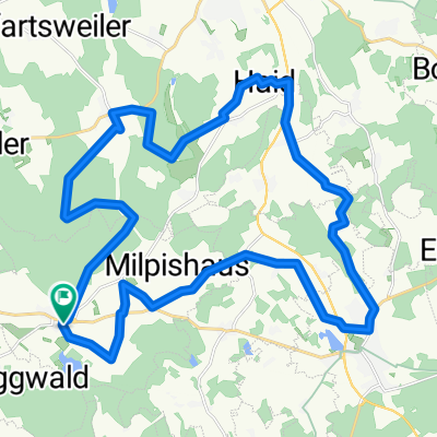
Höchsten von Hoßkirch aus
A cycling route starting in Hoßkirch, Baden-Württemberg, Germany.
Overview
About this route
Hoßkirch Hüttenreute Ri Hangen Eichstegen Kreenried Ebenweiler Ruprechtsbruck Fronhofen Ri Egg li Wengen Fenkenmühle Klitzistobel Oberwaldhausen Zogenweiler Schachen Bettenweiler Horgenzell re Winterbach Sattelbach re Firmetsweiler Urnau Limpach Wahlweiler Höchsten li Lichtenegg Krumbach Volzen re Ilmensee Pfrungen Riedhausen li Königseggwald re Hoßkirch
- -:--
- Duration
- 64.4 km
- Distance
- 525 m
- Ascent
- 525 m
- Descent
- ---
- Avg. speed
- ---
- Avg. speed

Route quality
Waytypes & surfaces along the route
Waytypes
Road
43.8 km
(68 %)
Busy road
7.7 km
(12 %)
Surfaces
Paved
57.1 km
(89 %)
Asphalt
57 km
(89 %)
Paved (undefined)
0.1 km
(<1 %)
Undefined
7.3 km
(11 %)
Continue with Bikemap
Use, edit, or download this cycling route
You would like to ride Höchsten von Hoßkirch aus or customize it for your own trip? Here is what you can do with this Bikemap route:
Free features
- Save this route as favorite or in collections
- Copy & plan your own version of this route
- Sync your route with Garmin or Wahoo
Premium features
Free trial for 3 days, or one-time payment. More about Bikemap Premium.
- Navigate this route on iOS & Android
- Export a GPX / KML file of this route
- Create your custom printout (try it for free)
- Download this route for offline navigation
Discover more Premium features.
Get Bikemap PremiumFrom our community
Other popular routes starting in Hoßkirch
 Rund um Hoßkirch - Atshausen und Saulgau
- Distance
- 32.1 km
- Ascent
- 171 m
- Descent
- 171 m
- Location
- Hoßkirch, Baden-Württemberg, Germany
 Höchsten von Hoßkirch aus
- Distance
- 64.4 km
- Ascent
- 525 m
- Descent
- 525 m
- Location
- Hoßkirch, Baden-Württemberg, Germany
 Bolstern - Lamprechtsweiler
- Distance
- 10.4 km
- Ascent
- 114 m
- Descent
- 121 m
- Location
- Hoßkirch, Baden-Württemberg, Germany
 Großer Dreiländer Radweg
- Distance
- 2.1 km
- Ascent
- 35 m
- Descent
- 41 m
- Location
- Hoßkirch, Baden-Württemberg, Germany
 Moderate route in Bad Saulgau
- Distance
- 25.8 km
- Ascent
- 325 m
- Descent
- 362 m
- Location
- Hoßkirch, Baden-Württemberg, Germany
 Hüttenreute Kressbronn
- Distance
- 88.8 km
- Ascent
- 545 m
- Descent
- 744 m
- Location
- Hoßkirch, Baden-Württemberg, Germany
 Rund um Hoßkirch - Atshausen und Saulgau
- Distance
- 32.1 km
- Ascent
- 272 m
- Descent
- 240 m
- Location
- Hoßkirch, Baden-Württemberg, Germany
 Durch Wald und Flur
- Distance
- 0.6 km
- Ascent
- 16 m
- Descent
- 0 m
- Location
- Hoßkirch, Baden-Württemberg, Germany
Open it in the app