Münstertal-Wiedener Eck-Haldenhof
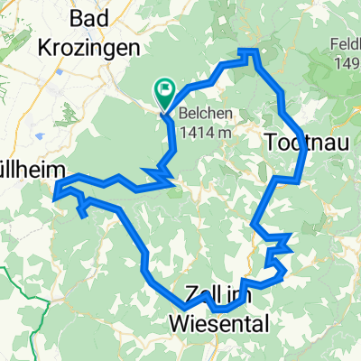
A cycling route starting in Münstertal, Black Forest, Baden-Württemberg, Germany.
Overview
About this route
Kurze Rennradtour über das Wiedener Eck nach Schönau und zurück über Neuenweg, Haldenhof ins Münstertal.
Kondition: mittel
Am Haldenhof ist eine Einkehr mit schönem Ausblick möglich.
- -:--
- Duration
- 53.7 km
- Distance
- 1,861 m
- Ascent
- 1,562 m
- Descent
- ---
- Avg. speed
- 1,054 m
- Avg. speed
Route quality
Waytypes & surfaces along the route
Waytypes
Busy road
39.9 km
(74 %)
Path
4.8 km
(9 %)
Surfaces
Paved
41.8 km
(78 %)
Unpaved
2.4 km
(5 %)
Asphalt
40 km
(74 %)
Paved (undefined)
1.7 km
(3 %)
Continue with Bikemap
Use, edit, or download this cycling route
You would like to ride Münstertal-Wiedener Eck-Haldenhof or customize it for your own trip? Here is what you can do with this Bikemap route:
Free features
- Save this route as favorite or in collections
- Copy & plan your own version of this route
- Sync your route with Garmin or Wahoo
Premium features
Free trial for 3 days, or one-time payment. More about Bikemap Premium.
- Navigate this route on iOS & Android
- Export a GPX / KML file of this route
- Create your custom printout (try it for free)
- Download this route for offline navigation
Discover more Premium features.
Get Bikemap PremiumFrom our community
Other popular routes starting in Münstertal
- Münstertal-Freiburg-St Peter-Titisee-Feldberg
- Distance
- 119.7 km
- Ascent
- 1,729 m
- Descent
- 1,729 m
- Location
- Münstertal, Black Forest, Baden-Württemberg, Germany
- Münstertal-Belchen-Münstertal
- Distance
- 58.1 km
- Ascent
- 1,536 m
- Descent
- 1,534 m
- Location
- Münstertal, Black Forest, Baden-Württemberg, Germany
- SwS2023-Bronzeroute
- Distance
- 110.4 km
- Ascent
- 4,843 m
- Descent
- 4,837 m
- Location
- Münstertal, Black Forest, Baden-Württemberg, Germany
- Schwarzwald-Rennrad-Marathon 2018 Bronze
- Distance
- 119.7 km
- Ascent
- 2,892 m
- Descent
- 2,883 m
- Location
- Münstertal, Black Forest, Baden-Württemberg, Germany
- Münstertal-Tegernau-Gresgen-Pfaffenberg-Frönd-Utzenfeld-WiedenerEck
- Distance
- 71 km
- Ascent
- 3,044 m
- Descent
- 3,045 m
- Location
- Münstertal, Black Forest, Baden-Württemberg, Germany
- Von Münstertal/Schwarzwald bis Bad Krozingen
- Distance
- 8.1 km
- Ascent
- 3 m
- Descent
- 105 m
- Location
- Münstertal, Black Forest, Baden-Württemberg, Germany
- "King or Queen of the valley"
- Distance
- 45.2 km
- Ascent
- 3,193 m
- Descent
- 3,190 m
- Location
- Münstertal, Black Forest, Baden-Württemberg, Germany
- Zur Grenze
- Distance
- 111.8 km
- Ascent
- 1,758 m
- Descent
- 1,724 m
- Location
- Münstertal, Black Forest, Baden-Württemberg, Germany
Open it in the app