

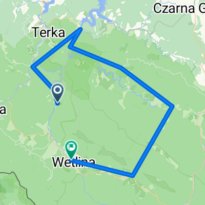
Podkarpacie2 - x - Cisna - Przełęcz Wyżnia
A cycling route starting in Cisna, Subcarpathian Voivodeship, Poland.
Overview
About this route
8:00 Cisna
9:30 Wyżnia Pass
PTTK Hostel Chatka Puchatka -> Smerek -> PTTK Hostel Chatka Puchatka
6h, 20km
16:30 Wyżnia Pass
18:00 Cisna
- -:--
- Duration
- 24.9 km
- Distance
- 436 m
- Ascent
- 123 m
- Descent
- ---
- Avg. speed
- ---
- Max. altitude

Route quality
Waytypes & surfaces along the route
Waytypes
Access road
0.2 km
(1 %)
Undefined
24.6 km
(99 %)
Surfaces
Paved
24.6 km
(99 %)
Asphalt
24.6 km
(99 %)
Undefined
0.2 km
(1 %)
Continue with Bikemap
Use, edit, or download this cycling route
You would like to ride Podkarpacie2 - x - Cisna - Przełęcz Wyżnia or customize it for your own trip? Here is what you can do with this Bikemap route:
Free features
- Save this route as favorite or in collections
- Copy & plan your own version of this route
- Sync your route with Garmin or Wahoo
Premium features
Free trial for 3 days, or one-time payment. More about Bikemap Premium.
- Navigate this route on iOS & Android
- Export a GPX / KML file of this route
- Create your custom printout (try it for free)
- Download this route for offline navigation
Discover more Premium features.
Get Bikemap PremiumFrom our community
Other popular routes starting in Cisna
 k pod Honem
- Distance
- 13.6 km
- Ascent
- 460 m
- Descent
- 469 m
- Location
- Cisna, Subcarpathian Voivodeship, Poland
 ride from Pastviny to Kalnica
- Distance
- 21.2 km
- Ascent
- 305 m
- Descent
- 303 m
- Location
- Cisna, Subcarpathian Voivodeship, Poland
 Cisna - Fereczata i Okrąglik
- Distance
- 34 km
- Ascent
- 790 m
- Descent
- 790 m
- Location
- Cisna, Subcarpathian Voivodeship, Poland
 Sine Wiry, Huculskie
- Distance
- 47.3 km
- Ascent
- 1,330 m
- Descent
- 1,286 m
- Location
- Cisna, Subcarpathian Voivodeship, Poland
 Smerek-Fereczata-Okrąglik-Jasło-Przysłup
- Distance
- 14.2 km
- Ascent
- 693 m
- Descent
- 654 m
- Location
- Cisna, Subcarpathian Voivodeship, Poland
 Pętla bieszczadzka
- Distance
- 100.8 km
- Ascent
- 1,157 m
- Descent
- 1,156 m
- Location
- Cisna, Subcarpathian Voivodeship, Poland
 Dookoła Masywu Hyrlatej.
- Distance
- 29.1 km
- Ascent
- 491 m
- Descent
- 492 m
- Location
- Cisna, Subcarpathian Voivodeship, Poland
 Stakcin, Słowacja
- Distance
- 28.8 km
- Ascent
- 212 m
- Descent
- 654 m
- Location
- Cisna, Subcarpathian Voivodeship, Poland
Open it in the app