

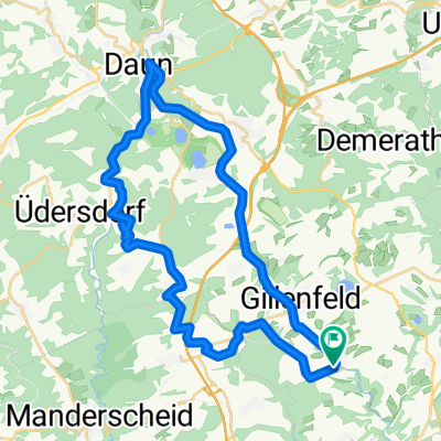
Strohn Winkel Wollmerath Ellscheid Gillenfeld Strohn
A cycling route starting in Strohn, Rhineland-Palatinate, Germany.
Overview
About this route
- -:--
- Duration
- 23.9 km
- Distance
- 348 m
- Ascent
- 342 m
- Descent
- ---
- Avg. speed
- ---
- Max. altitude
Route quality
Waytypes & surfaces along the route
Waytypes
Track
17 km
(71 %)
Road
3.6 km
(15 %)
Surfaces
Paved
12 km
(50 %)
Unpaved
10 km
(42 %)
Asphalt
11.5 km
(48 %)
Gravel
4.8 km
(20 %)
Continue with Bikemap
Use, edit, or download this cycling route
You would like to ride Strohn Winkel Wollmerath Ellscheid Gillenfeld Strohn or customize it for your own trip? Here is what you can do with this Bikemap route:
Free features
- Save this route as favorite or in collections
- Copy & plan your own version of this route
- Sync your route with Garmin or Wahoo
Premium features
Free trial for 3 days, or one-time payment. More about Bikemap Premium.
- Navigate this route on iOS & Android
- Export a GPX / KML file of this route
- Create your custom printout (try it for free)
- Download this route for offline navigation
Discover more Premium features.
Get Bikemap PremiumFrom our community
Other popular routes starting in Strohn
 Strohn - Udler - Brockscheid - Eckfeld - MMR Gillfeld
- Distance
- 20.5 km
- Ascent
- 271 m
- Descent
- 280 m
- Location
- Strohn, Rhineland-Palatinate, Germany
 Radrunde durch Strohn
- Distance
- 17.2 km
- Ascent
- 240 m
- Descent
- 240 m
- Location
- Strohn, Rhineland-Palatinate, Germany
 Ausfahrt durch Strohn
- Distance
- 14.8 km
- Ascent
- 191 m
- Descent
- 195 m
- Location
- Strohn, Rhineland-Palatinate, Germany
 Lavabombe
- Distance
- 25.6 km
- Ascent
- 315 m
- Descent
- 321 m
- Location
- Strohn, Rhineland-Palatinate, Germany
 track1- Strohn
- Distance
- 36.5 km
- Ascent
- 343 m
- Descent
- 342 m
- Location
- Strohn, Rhineland-Palatinate, Germany
 Ausfahrt durch Strohn
- Distance
- 28.5 km
- Ascent
- 400 m
- Descent
- 413 m
- Location
- Strohn, Rhineland-Palatinate, Germany
 Stromer Märchen, Immerather Maar, Strotzbüsch, Sprink, Strohn
- Distance
- 17 km
- Ascent
- 249 m
- Descent
- 247 m
- Location
- Strohn, Rhineland-Palatinate, Germany
 "lockere" Freitag abend runde
- Distance
- 27.9 km
- Ascent
- 245 m
- Descent
- 256 m
- Location
- Strohn, Rhineland-Palatinate, Germany
Open it in the app