
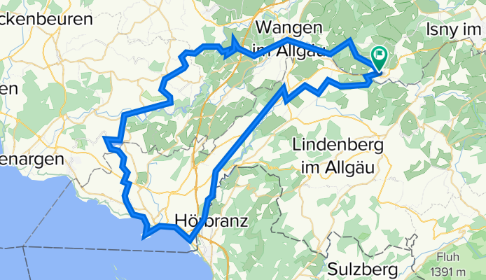
ALLGÄU 001: Eglofs - Lindau - Wangen - Eglofs
A cycling route starting in Heimenkirch, Bavaria, Germany.
Overview
About this route
Eglofs - BK - Maria Thann - BK - Hergatz - BK - Lindau (Bodensee) - BK/BSR - Bad Schachen - Enzisweiler - Bodolz - Taubenberg - Unterreitnau - Degersee - DoB - Busenhaus - DoB - Hiltensweiler - DoB - Oberlangnau - DoB - Oberlangensee - DoB - Neukirch - DoB - Haslach - DoB - Rhein - DoB - Niederwangen - DoB - Wangen - DoB - Gießen - DoB - Eglofs
- -:--
- Duration
- 78 km
- Distance
- 511 m
- Ascent
- 511 m
- Descent
- ---
- Avg. speed
- ---
- Avg. speed
Route quality
Waytypes & surfaces along the route
Waytypes
Quiet road
40.6 km
(52 %)
Road
22.1 km
(28 %)
Surfaces
Paved
70.5 km
(90 %)
Unpaved
0.8 km
(<1 %)
Asphalt
70.2 km
(90 %)
Ground
0.6 km
(<1 %)
Continue with Bikemap
Use, edit, or download this cycling route
You would like to ride ALLGÄU 001: Eglofs - Lindau - Wangen - Eglofs or customize it for your own trip? Here is what you can do with this Bikemap route:
Free features
- Save this route as favorite or in collections
- Copy & plan your own version of this route
- Sync your route with Garmin or Wahoo
Premium features
Free trial for 3 days, or one-time payment. More about Bikemap Premium.
- Navigate this route on iOS & Android
- Export a GPX / KML file of this route
- Create your custom printout (try it for free)
- Download this route for offline navigation
Discover more Premium features.
Get Bikemap PremiumFrom our community
Other popular routes starting in Heimenkirch
 Färberstraße 33, Lindenberg im Allgäu nach Färberstraße 35, Lindenberg im Allgäu
- Distance
- 19.2 km
- Ascent
- 239 m
- Descent
- 238 m
- Location
- Heimenkirch, Bavaria, Germany
 ALLGÄU 002: Eglofser Allgäurunde
- Distance
- 36 km
- Ascent
- 399 m
- Descent
- 400 m
- Location
- Heimenkirch, Bavaria, Germany
 Bodensee mittel
- Distance
- 214.5 km
- Ascent
- 433 m
- Descent
- 433 m
- Location
- Heimenkirch, Bavaria, Germany
 WG-LI-Weiler-Ellhofen-Gest-Eisen
- Distance
- 27 km
- Ascent
- 481 m
- Descent
- 554 m
- Location
- Heimenkirch, Bavaria, Germany
 MwS-Lindenberg Scheidegg-Weiler Oberhäuser-Tour
- Distance
- 21.4 km
- Ascent
- 253 m
- Descent
- 253 m
- Location
- Heimenkirch, Bavaria, Germany
 Kemptener Straße 17, Heimenkirch nach B32 5, Opfenbach
- Distance
- 7.4 km
- Ascent
- 19 m
- Descent
- 171 m
- Location
- Heimenkirch, Bavaria, Germany
 Sylvia
- Distance
- 61.9 km
- Ascent
- 270 m
- Descent
- 500 m
- Location
- Heimenkirch, Bavaria, Germany
 Lindenberg zum Pfaender
- Distance
- 16.3 km
- Ascent
- 416 m
- Descent
- 133 m
- Location
- Heimenkirch, Bavaria, Germany
Open it in the app