

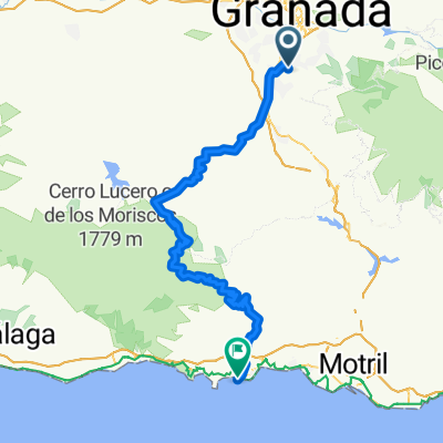
Gójar a Pinos Genil
A cycling route starting in Gójar, Andalusia, Spain.
Overview
About this route
Ruta desde Gójar, Granada y Pinos Genil
- -:--
- Duration
- 43.9 km
- Distance
- 297 m
- Ascent
- 300 m
- Descent
- ---
- Avg. speed
- ---
- Max. altitude

Continue with Bikemap
Use, edit, or download this cycling route
You would like to ride Gójar a Pinos Genil or customize it for your own trip? Here is what you can do with this Bikemap route:
Free features
- Save this route as favorite or in collections
- Copy & plan your own version of this route
- Sync your route with Garmin or Wahoo
Premium features
Free trial for 3 days, or one-time payment. More about Bikemap Premium.
- Navigate this route on iOS & Android
- Export a GPX / KML file of this route
- Create your custom printout (try it for free)
- Download this route for offline navigation
Discover more Premium features.
Get Bikemap PremiumFrom our community
Other popular routes starting in Gójar
 GR209-Collado del Fraile-15/03/09
- Distance
- 23.4 km
- Ascent
- 791 m
- Descent
- 505 m
- Location
- Gójar, Andalusia, Spain
 LOMA LINDA - OTURA - CAÑADAS DEL PARQUE - DILAR - LOMA LINDA
- Distance
- 32.8 km
- Ascent
- 407 m
- Descent
- 406 m
- Location
- Gójar, Andalusia, Spain
 LOMA LINDA - ALMUÑECAR
- Distance
- 89.9 km
- Ascent
- 1,344 m
- Descent
- 2,088 m
- Location
- Gójar, Andalusia, Spain
 Ogijares - Hermita Vieja
- Distance
- 28 km
- Ascent
- 763 m
- Descent
- 668 m
- Location
- Gójar, Andalusia, Spain
 LOMA LINDA-GRANADA-GUEJAR SIERRA-DORNAJO-PURCHE-GRANADA
- Distance
- 62.1 km
- Ascent
- 1,264 m
- Descent
- 1,335 m
- Location
- Gójar, Andalusia, Spain
 Tour Gójar Otura Dílar
- Distance
- 19.2 km
- Ascent
- 274 m
- Descent
- 193 m
- Location
- Gójar, Andalusia, Spain
 Rio Dílar
- Distance
- 25.6 km
- Ascent
- 870 m
- Descent
- 803 m
- Location
- Gójar, Andalusia, Spain
 De Gójar al rio Dílar
- Distance
- 21 km
- Ascent
- 340 m
- Descent
- 393 m
- Location
- Gójar, Andalusia, Spain
Open it in the app