

Roggenburg - Illertissen - Weissenhorn
A cycling route starting in Roggenburg, Bavaria, Germany.
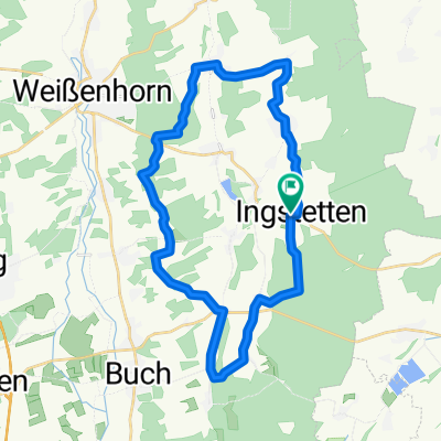
Overview
About this route
31.08.2016 Cycling tour Haltmayer & Mayer
- -:--
- Duration
- 51.2 km
- Distance
- 258 m
- Ascent
- 258 m
- Descent
- ---
- Avg. speed
- ---
- Max. altitude

Route quality
Waytypes & surfaces along the route
Waytypes
Road
13.3 km
(26 %)
Quiet road
13.3 km
(26 %)
Surfaces
Paved
35.3 km
(69 %)
Unpaved
5.6 km
(11 %)
Asphalt
34.8 km
(68 %)
Gravel
5.6 km
(11 %)
Continue with Bikemap
Use, edit, or download this cycling route
You would like to ride Roggenburg - Illertissen - Weissenhorn or customize it for your own trip? Here is what you can do with this Bikemap route:
Free features
- Save this route as favorite or in collections
- Copy & plan your own version of this route
- Sync your route with Garmin or Wahoo
Premium features
Free trial for 3 days, or one-time payment. More about Bikemap Premium.
- Navigate this route on iOS & Android
- Export a GPX / KML file of this route
- Create your custom printout (try it for free)
- Download this route for offline navigation
Discover more Premium features.
Get Bikemap PremiumFrom our community
Other popular routes starting in Roggenburg
 SV Biberach 100er am 1.8.2010
- Distance
- 108.2 km
- Ascent
- 670 m
- Descent
- 670 m
- Location
- Roggenburg, Bavaria, Germany
 Rhododendron-Tour
- Distance
- 75.3 km
- Ascent
- 985 m
- Descent
- 986 m
- Location
- Roggenburg, Bavaria, Germany
 Buchenweg 5, Roggenburg nach Buchenweg 5, Roggenburg
- Distance
- 34.4 km
- Ascent
- 312 m
- Descent
- 312 m
- Location
- Roggenburg, Bavaria, Germany
 rund um den Roggenburger Weiher
- Distance
- 11.2 km
- Ascent
- 152 m
- Descent
- 150 m
- Location
- Roggenburg, Bavaria, Germany
 SV Biberafch 100er-Tour (111 km)
- Distance
- 111.4 km
- Ascent
- 566 m
- Descent
- 581 m
- Location
- Roggenburg, Bavaria, Germany
 Panoramarunde um Roggenburg
- Distance
- 29.8 km
- Ascent
- 225 m
- Descent
- 225 m
- Location
- Roggenburg, Bavaria, Germany
 Einkaufen in Weißenhorn und Flucht vor dem Gewitter...
- Distance
- 14.3 km
- Ascent
- 120 m
- Descent
- 110 m
- Location
- Roggenburg, Bavaria, Germany
 1 Tour
- Distance
- 13.4 km
- Ascent
- 423 m
- Descent
- 440 m
- Location
- Roggenburg, Bavaria, Germany
Open it in the app