

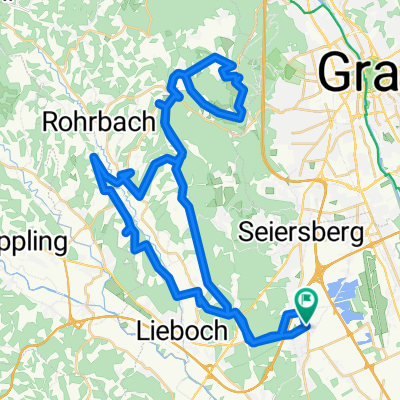
Steiermark 2 - Westl. Steiermark
A cycling route starting in Unterpremstätten, Styria, Austria.
Overview
About this route
TEASI track Unterpremstätten-Södingberg-Hitzendorf-Eben-Thaler See-Thal-Mausser Most-Unterpremstätten
- -:--
- Duration
- 56.4 km
- Distance
- 535 m
- Ascent
- 535 m
- Descent
- ---
- Avg. speed
- ---
- Max. altitude

Route quality
Waytypes & surfaces along the route
Waytypes
Quiet road
25.2 km
(45 %)
Busy road
17.4 km
(31 %)
Surfaces
Paved
19.9 km
(35 %)
Unpaved
1.5 km
(3 %)
Asphalt
19.8 km
(35 %)
Gravel
1.5 km
(3 %)
Route highlights
Points of interest along the route
Point of interest after 3.7 km
Mausser Most
Point of interest after 3.7 km
Arnold Schwarzenegger Geburtshaus
Point of interest after 3.7 km
Erwins Geburtshaus
Continue with Bikemap
Use, edit, or download this cycling route
You would like to ride Steiermark 2 - Westl. Steiermark or customize it for your own trip? Here is what you can do with this Bikemap route:
Free features
- Save this route as favorite or in collections
- Copy & plan your own version of this route
- Sync your route with Garmin or Wahoo
Premium features
Free trial for 3 days, or one-time payment. More about Bikemap Premium.
- Navigate this route on iOS & Android
- Export a GPX / KML file of this route
- Create your custom printout (try it for free)
- Download this route for offline navigation
Discover more Premium features.
Get Bikemap PremiumFrom our community
Other popular routes starting in Unterpremstätten
 Steiermark 3 - Südliche Mur
- Distance
- 76.7 km
- Ascent
- 172 m
- Descent
- 176 m
- Location
- Unterpremstätten, Styria, Austria
 Über die süd-westl Hügeln
- Distance
- 54 km
- Ascent
- 564 m
- Descent
- 564 m
- Location
- Unterpremstätten, Styria, Austria
 Schwarzlsee - Wildon - Kirchberg - St. Margarethen - Nestelbach - Schwarzlsee
- Distance
- 88.4 km
- Ascent
- 946 m
- Descent
- 953 m
- Location
- Unterpremstätten, Styria, Austria
 Kalsdorf - Muttendorf - Dobl - Unterpremstätten
- Distance
- 46.9 km
- Ascent
- 239 m
- Descent
- 249 m
- Location
- Unterpremstätten, Styria, Austria
 Steiermark 2 - Westl. Steiermark
- Distance
- 56.4 km
- Ascent
- 535 m
- Descent
- 535 m
- Location
- Unterpremstätten, Styria, Austria
 Steiermark 2 - Westl. Steiermark
- Distance
- 56.4 km
- Ascent
- 528 m
- Descent
- 528 m
- Location
- Unterpremstätten, Styria, Austria
 Die West-Tour
- Distance
- 76.9 km
- Ascent
- 1,066 m
- Descent
- 1,064 m
- Location
- Unterpremstätten, Styria, Austria
 Glocknerman 2014
- Distance
- 1,054.8 km
- Ascent
- 7,201 m
- Descent
- 7,201 m
- Location
- Unterpremstätten, Styria, Austria
Open it in the app