
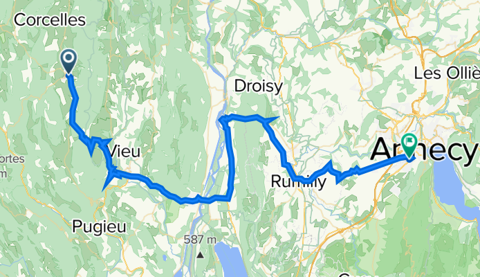
2016 Ride Day 145 - Hauteville-Lompnes to Seynod (Annecy)
A cycling route starting in Hauteville-Lompnes, Auvergne-Rhône-Alpes, France.
Overview
About this route
Great ride through wonderful countryside on mostly outstanding roads. D991 had excellent bike lanes. D16, especially as it neared Annecy, had more traffic than one would like, but it wasn't bad.
The downhill from Col de la Lèbe was superb. Beautiful.
- -:--
- Duration
- 75.2 km
- Distance
- 644 m
- Ascent
- 936 m
- Descent
- ---
- Avg. speed
- ---
- Max. altitude

Route photos
\"")
\"")
\"")
\"")
\"")
Route quality
Waytypes & surfaces along the route
Waytypes
Road
12.8 km
(17 %)
Quiet road
2.3 km
(3 %)
Surfaces
Paved
21.8 km
(29 %)
Asphalt
21.8 km
(29 %)
Undefined
53.4 km
(71 %)
Continue with Bikemap
Use, edit, or download this cycling route
You would like to ride 2016 Ride Day 145 - Hauteville-Lompnes to Seynod (Annecy) or customize it for your own trip? Here is what you can do with this Bikemap route:
Free features
- Save this route as favorite or in collections
- Copy & plan your own version of this route
- Sync your route with Garmin or Wahoo
Premium features
Free trial for 3 days, or one-time payment. More about Bikemap Premium.
- Navigate this route on iOS & Android
- Export a GPX / KML file of this route
- Create your custom printout (try it for free)
- Download this route for offline navigation
Discover more Premium features.
Get Bikemap PremiumFrom our community
Other popular routes starting in Hauteville-Lompnes
 Richemond - Biche - Colombier
- Distance
- 110.1 km
- Ascent
- 2,641 m
- Descent
- 2,648 m
- Location
- Hauteville-Lompnes, Auvergne-Rhône-Alpes, France
 depuis Hauteville lompnes
- Distance
- 17.9 km
- Ascent
- 162 m
- Descent
- 550 m
- Location
- Hauteville-Lompnes, Auvergne-Rhône-Alpes, France
 Route des Lésines, Haut Valromey à Place de Chanta la Vieille, Giron
- Distance
- 41.9 km
- Ascent
- 1,125 m
- Descent
- 844 m
- Location
- Hauteville-Lompnes, Auvergne-Rhône-Alpes, France
 2016 Ride Day 145 - Hauteville-Lompnes to Seynod (Annecy)
- Distance
- 75.2 km
- Ascent
- 644 m
- Descent
- 936 m
- Location
- Hauteville-Lompnes, Auvergne-Rhône-Alpes, France
 brenod
- Distance
- 26.5 km
- Ascent
- 513 m
- Descent
- 572 m
- Location
- Hauteville-Lompnes, Auvergne-Rhône-Alpes, France
 TdF 4
TdF 4- Distance
- 110.2 km
- Ascent
- 1,913 m
- Descent
- 2,435 m
- Location
- Hauteville-Lompnes, Auvergne-Rhône-Alpes, France
 Ruffieu-Vieille Lèbe--Virieu-Culoz-Richemond
- Distance
- 92.4 km
- Ascent
- 1,356 m
- Descent
- 1,356 m
- Location
- Hauteville-Lompnes, Auvergne-Rhône-Alpes, France
 7bis VJ La Praille - Chambéry
- Distance
- 103.2 km
- Ascent
- 1,941 m
- Descent
- 2,457 m
- Location
- Hauteville-Lompnes, Auvergne-Rhône-Alpes, France
Open it in the app