2016_09_03 Brdský Himalája
A cycling route starting in Spálené Poříčí, Plzeň Region, Czechia.
Overview
About this route
TEASI track - jedenáctkrát na vrcholu během dne...vlastně dvanáctkrát, v Nepálu to byl gurmánský vrchol...
- -:--
- Duration
- 59.6 km
- Distance
- 1,084 m
- Ascent
- 1,084 m
- Descent
- ---
- Avg. speed
- ---
- Max. altitude
Route quality
Waytypes & surfaces along the route
Waytypes
Track
31.6 km
(53 %)
Quiet road
18.5 km
(31 %)
Surfaces
Paved
25 km
(42 %)
Unpaved
20.3 km
(34 %)
Asphalt
20.9 km
(35 %)
Ground
8.9 km
(15 %)
Route highlights
Points of interest along the route

Photo after 0.1 km
Rudí řádí nad Míšovem

Photo after 9.7 km
Kočka 789mnm

Point of interest after 9.9 km
Kočka POI

Point of interest after 17.6 km
Koruna II 832mnm

Point of interest after 18.2 km
Koruna I 837mnm

Point of interest after 22.3 km
Bohutínský vrch 843mnm

Point of interest after 23.8 km
Brdce 839mnm

Point of interest after 28.6 km
Hradiště 840mnm

Point of interest after 29.8 km
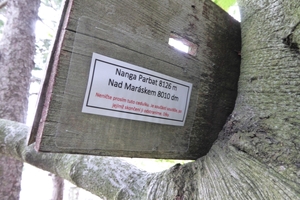
Na Pateráku 836mnm

Point of interest after 30.9 km
Malý Tok 844mnm

Point of interest after 33.8 km
Praha 862mnm

Point of interest after 37.3 km
Nepál 8000mnm (2piva + 2hořké)

Point of interest after 49 km
Třemšín 827mnm

Point of interest after 56.1 km
Nad Maráskem 801mnm
Continue with Bikemap
Use, edit, or download this cycling route
You would like to ride 2016_09_03 Brdský Himalája or customize it for your own trip? Here is what you can do with this Bikemap route:
Free features
- Save this route as favorite or in collections
- Copy & plan your own version of this route
- Sync your route with Garmin or Wahoo
Premium features
Free trial for 3 days, or one-time payment. More about Bikemap Premium.
- Navigate this route on iOS & Android
- Export a GPX / KML file of this route
- Create your custom printout (try it for free)
- Download this route for offline navigation
Discover more Premium features.
Get Bikemap PremiumFrom our community
Other popular routes starting in Spálené Poříčí
 Míšov-Padrť-Strašice-Míšov
- Distance
- 36.5 km
- Ascent
- 390 m
- Descent
- 377 m
- Location
- Spálené Poříčí, Plzeň Region, Czechia
 2013_09_07 Na Brdy
- Distance
- 50.9 km
- Ascent
- 686 m
- Descent
- 686 m
- Location
- Spálené Poříčí, Plzeň Region, Czechia
 Lučiště - Míšov - Padrťské rybníky - Lučiště
- Distance
- 29.2 km
- Ascent
- 364 m
- Descent
- 366 m
- Location
- Spálené Poříčí, Plzeň Region, Czechia
 Cicov - Padrte - Cicov
- Distance
- 26.2 km
- Ascent
- 406 m
- Descent
- 406 m
- Location
- Spálené Poříčí, Plzeň Region, Czechia
 2016_09_03 Brdský Himalája
- Distance
- 59.6 km
- Ascent
- 1,084 m
- Descent
- 1,084 m
- Location
- Spálené Poříčí, Plzeň Region, Czechia
 2017_06_03 Míšov-Kakejcov-Míšov
- Distance
- 45.9 km
- Ascent
- 741 m
- Descent
- 740 m
- Location
- Spálené Poříčí, Plzeň Region, Czechia
 Trans Prdy - pokus č. 1 (neúspěšný)
- Distance
- 67.6 km
- Ascent
- 811 m
- Descent
- 1,039 m
- Location
- Spálené Poříčí, Plzeň Region, Czechia
 2018_09_15 Brdy Míšov
- Distance
- 51.2 km
- Ascent
- 523 m
- Descent
- 522 m
- Location
- Spálené Poříčí, Plzeň Region, Czechia
Open it in the app


