

AX2016 Tag 4 Rabenstein-Frau im Walde 64 km 1930 Hm
A cycling route starting in Moos in Passeier, Trentino-Alto Adige, Italy.
Overview
About this route
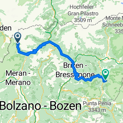
31.8.2016 4th Day Rabenstein-Frau im Walde, 60 Km 2215 Hm, dry, cloudy
After Rabenstein we took a detour because the bridge was being renewed, hence this track. At Seehof, we went along a nice trail to Moos. At Moos, one follows another trail to the Stieber Waterfall, although unfortunately after the waterfall there is a short pushing section to plan for. Then we move onto the Merano High Route at 1150 m over a steady 6 km ascent with about 400 Hm. After that, the route runs parallel to the Passeira River; slightly descending, it is wonderful to ride with beautiful views. In Merano, you can refuel and watch the goings-on in the city. From Lana, it goes up to the Gampen Pass at 1518 m above sea level; a warning, 15 kilometers of ascent, 1250 Hm in a row with some steep ramps, possibly some pushing sections included; only at Pichler Hof do you reach the asphalt road with a steady incline. After the Gampen Pass, it’s a roll down to Unsere Liebe Frau im Walde. We stayed at the inn Zum Hirschen, great food, accommodation old but OK, and laundry service for only 7.50 euros.
- -:--
- Duration
- 63.6 km
- Distance
- 1,523 m
- Ascent
- 1,580 m
- Descent
- ---
- Avg. speed
- ---
- Max. altitude

Route highlights
Points of interest along the route
Point of interest after 1.4 km
Umleitung wegen Brückenbau
Point of interest after 7.4 km
Stieber Wasserfall
Point of interest after 14 km
Meraner Höhenweg 1191m
Point of interest after 60.6 km
Gampenpass 1518 m
Point of interest after 63.6 km
Gasthof Zum Hirschen http://www.zumhirschen.com/
Continue with Bikemap
Use, edit, or download this cycling route
You would like to ride AX2016 Tag 4 Rabenstein-Frau im Walde 64 km 1930 Hm or customize it for your own trip? Here is what you can do with this Bikemap route:
Free features
- Save this route as favorite or in collections
- Copy & plan your own version of this route
- Sync your route with Garmin or Wahoo
Premium features
Free trial for 3 days, or one-time payment. More about Bikemap Premium.
- Navigate this route on iOS & Android
- Export a GPX / KML file of this route
- Create your custom printout (try it for free)
- Download this route for offline navigation
Discover more Premium features.
Get Bikemap PremiumFrom our community
Other popular routes starting in Moos in Passeier
 transalp2010_3
- Distance
- 163.9 km
- Ascent
- 2,300 m
- Descent
- 3,484 m
- Location
- Moos in Passeier, Trentino-Alto Adige, Italy
 AX2016 Tag 4 Rabenstein-Frau im Walde 64 km 1930 Hm
- Distance
- 63.6 km
- Ascent
- 1,523 m
- Descent
- 1,580 m
- Location
- Moos in Passeier, Trentino-Alto Adige, Italy
 Ötz: Timmelsjoch Auffahrt SO
- Distance
- 17.5 km
- Ascent
- 1,360 m
- Descent
- 314 m
- Location
- Moos in Passeier, Trentino-Alto Adige, Italy
 Timmelsjoch-Pfelders
- Distance
- 22 km
- Ascent
- 966 m
- Descent
- 863 m
- Location
- Moos in Passeier, Trentino-Alto Adige, Italy
 Oesterreich - Dolomiti 3/7
- Distance
- 130.6 km
- Ascent
- 3,898 m
- Descent
- 4,101 m
- Location
- Moos in Passeier, Trentino-Alto Adige, Italy
 Moos - Arnoga
- Distance
- 137.7 km
- Ascent
- 3,053 m
- Descent
- 2,178 m
- Location
- Moos in Passeier, Trentino-Alto Adige, Italy
 Ulfaser Alm ab Platt
- Distance
- 21.2 km
- Ascent
- 484 m
- Descent
- 1,120 m
- Location
- Moos in Passeier, Trentino-Alto Adige, Italy
 Ulfaser Waalweg
- Distance
- 9.9 km
- Ascent
- 120 m
- Descent
- 564 m
- Location
- Moos in Passeier, Trentino-Alto Adige, Italy
Open it in the app