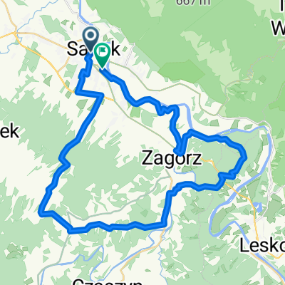
Niebieski szlak Sanok - SuliĆa
A cycling route starting in Sanok, Subcarpathian Voivodeship, Poland.
Overview
About this route
Sanok - TurzaĆsk - Smolnik - KomaĆcza - Kulaszne
- -:--
- Duration
- 94 km
- Distance
- 1,093 m
- Ascent
- 1,093 m
- Descent
- ---
- Avg. speed
- ---
- Max. altitude
Route quality
Waytypes & surfaces along the route
Waytypes
Quiet road
27.3 km
(29 %)
Track
16.9 km
(18 %)
Surfaces
Paved
73.3 km
(78 %)
Unpaved
15 km
(16 %)
Asphalt
71.4 km
(76 %)
Ground
15 km
(16 %)
Continue with Bikemap
Use, edit, or download this cycling route
You would like to ride Niebieski szlak Sanok - SuliĆa or customize it for your own trip? Here is what you can do with this Bikemap route:
Free features
- Save this route as favorite or in collections
- Copy & plan your own version of this route
- Split it into stages to create a multi-day tour
- Sync your route with Garmin or Wahoo
Premium features
Free trial for 3 days, or one-time payment. More about Bikemap Premium.
- Navigate this route on iOS & Android
- Export a GPX / KML file of this route
- Create your custom printout (try it for free)
- Download this route for offline navigation
Discover more Premium features.
Get Bikemap PremiumFrom our community
Other popular routes starting in Sanok
- z Sanoka do PolaĆczyka
- Distance
- 31.4 km
- Ascent
- 445 m
- Descent
- 283 m
- Location
- Sanok, Subcarpathian Voivodeship, Poland
- Velo San Promo Tour 2021 part 1
- Distance
- 27.5 km
- Ascent
- 228 m
- Descent
- 187 m
- Location
- Sanok, Subcarpathian Voivodeship, Poland
- Szkolna 2, Sanok do Szkolna 2, Sanok
- Distance
- 22 km
- Ascent
- 242 m
- Descent
- 253 m
- Location
- Sanok, Subcarpathian Voivodeship, Poland
- Langiewicza 10, Sanok do Langiewicza 3, Sanok
- Distance
- 19.4 km
- Ascent
- 209 m
- Descent
- 245 m
- Location
- Sanok, Subcarpathian Voivodeship, Poland
- Langiewicza 3, Sanok do Langiewicza 3, Sanok
- Distance
- 23.4 km
- Ascent
- 562 m
- Descent
- 562 m
- Location
- Sanok, Subcarpathian Voivodeship, Poland
- Langiewicza 1, Sanok do Langiewicza 10, Sanok
- Distance
- 27.9 km
- Ascent
- 530 m
- Descent
- 567 m
- Location
- Sanok, Subcarpathian Voivodeship, Poland
- wokĂłĆ GĂłr SĆonnych
- Distance
- 63.5 km
- Ascent
- 468 m
- Descent
- 468 m
- Location
- Sanok, Subcarpathian Voivodeship, Poland
- Jana PawĆa II 58A, Sanok do Langiewicza 3, Sanok
- Distance
- 36.2 km
- Ascent
- 854 m
- Descent
- 852 m
- Location
- Sanok, Subcarpathian Voivodeship, Poland
Open it in the app