Eilenburg - Riesa
A cycling route starting in Eilenburg, Saxony, Germany.
Overview
About this route
- -:--
- Duration
- 80.4 km
- Distance
- 229 m
- Ascent
- 240 m
- Descent
- ---
- Avg. speed
- ---
- Max. altitude
Route quality
Waytypes & surfaces along the route
Waytypes
Quiet road
28.8 km
(36 %)
Track
15.9 km
(20 %)
Surfaces
Paved
66.3 km
(82 %)
Unpaved
9.6 km
(12 %)
Asphalt
60.9 km
(76 %)
Gravel
5.3 km
(7 %)
Route highlights
Points of interest along the route
Accommodation after 70.6 km
Pension Zur Nixe EZ/Fr. 32,- €
Accommodation after 70.6 km
Links zur Pension Zur Nixe, Am Wasserturm 16a
Continue with Bikemap
Use, edit, or download this cycling route
You would like to ride Eilenburg - Riesa or customize it for your own trip? Here is what you can do with this Bikemap route:
Free features
- Save this route as favorite or in collections
- Copy & plan your own version of this route
- Split it into stages to create a multi-day tour
- Sync your route with Garmin or Wahoo
Premium features
Free trial for 3 days, or one-time payment. More about Bikemap Premium.
- Navigate this route on iOS & Android
- Export a GPX / KML file of this route
- Create your custom printout (try it for free)
- Download this route for offline navigation
Discover more Premium features.
Get Bikemap PremiumFrom our community
Other popular routes starting in Eilenburg
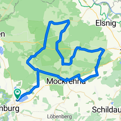
- Muldentalradweg - Teil2; Eilenburg-Döbeln
- Distance
- 80.3 km
- Ascent
- 201 m
- Descent
- 139 m
- Location
- Eilenburg, Saxony, Germany
- Eilenburg - Storbeck
- Distance
- 318 km
- Ascent
- 281 m
- Descent
- 334 m
- Location
- Eilenburg, Saxony, Germany
- Eilenburg - Riesa
- Distance
- 80.4 km
- Ascent
- 229 m
- Descent
- 240 m
- Location
- Eilenburg, Saxony, Germany
- 6 - Eilenburg - Dessau / Mulderadweg
- Distance
- 82 km
- Ascent
- 73 m
- Descent
- 115 m
- Location
- Eilenburg, Saxony, Germany
- Mulderadweg - Abschnitt Eilenburg bis Bad Düben (Vereinigte Mulde)
- Distance
- 19.1 km
- Ascent
- 20 m
- Descent
- 30 m
- Location
- Eilenburg, Saxony, Germany
- Dörfer Nordsachsens
- Distance
- 62.8 km
- Ascent
- 178 m
- Descent
- 179 m
- Location
- Eilenburg, Saxony, Germany
- Südlicher Rand Dübener Heide
- Distance
- 63.2 km
- Ascent
- 136 m
- Descent
- 137 m
- Location
- Eilenburg, Saxony, Germany
- D-B 21 a Eilenburg - Dessau
- Distance
- 74.7 km
- Ascent
- 88 m
- Descent
- 128 m
- Location
- Eilenburg, Saxony, Germany
Open it in the app