

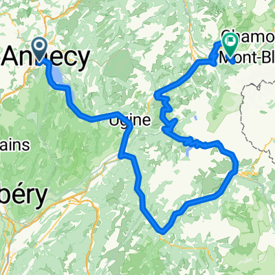
2016 Ride Day 146 - Seynod (Annecy) - Circle to Ugine
A cycling route starting in Cran-Gevrier, Auvergne-Rhône-Alpes, France.
Overview
About this route
Wonderful bike path along west side of lake and all the way to Ugine. Ride back along east side of lake had some path and some road without shoulder, but not too bad. Great ride with stunning scenery.
Highly recommend.
- -:--
- Duration
- 79.5 km
- Distance
- 360 m
- Ascent
- 360 m
- Descent
- ---
- Avg. speed
- ---
- Max. altitude

Route photos
 - Circle to Ugine\"")
 - Circle to Ugine\"")
 - Circle to Ugine\"")
Route quality
Waytypes & surfaces along the route
Waytypes
Cycleway
56 km
(70 %)
Busy road
10.9 km
(14 %)
Surfaces
Paved
65.1 km
(82 %)
Unpaved
1.6 km
(2 %)
Asphalt
64.5 km
(81 %)
Ground
1.4 km
(2 %)
Continue with Bikemap
Use, edit, or download this cycling route
You would like to ride 2016 Ride Day 146 - Seynod (Annecy) - Circle to Ugine or customize it for your own trip? Here is what you can do with this Bikemap route:
Free features
- Save this route as favorite or in collections
- Copy & plan your own version of this route
- Sync your route with Garmin or Wahoo
Premium features
Free trial for 3 days, or one-time payment. More about Bikemap Premium.
- Navigate this route on iOS & Android
- Export a GPX / KML file of this route
- Create your custom printout (try it for free)
- Download this route for offline navigation
Discover more Premium features.
Get Bikemap PremiumFrom our community
Other popular routes starting in Cran-Gevrier
 Annecy - Forclaz - Semnoz - Annecy
- Distance
- 86.4 km
- Ascent
- 1,871 m
- Descent
- 1,867 m
- Location
- Cran-Gevrier, Auvergne-Rhône-Alpes, France
 Annecy
- Distance
- 57.5 km
- Ascent
- 1,451 m
- Descent
- 1,448 m
- Location
- Cran-Gevrier, Auvergne-Rhône-Alpes, France
 Day 8: Saint-Rambert-En-Bugey
- Distance
- 101.3 km
- Ascent
- 810 m
- Descent
- 995 m
- Location
- Cran-Gevrier, Auvergne-Rhône-Alpes, France
 2016 Ride Day 148 - Seynod (Annecy) - Circle through Col de Leschaux 2
- Distance
- 42.2 km
- Ascent
- 579 m
- Descent
- 579 m
- Location
- Cran-Gevrier, Auvergne-Rhône-Alpes, France
 Cormet de Roselend 20.05.2012
- Distance
- 217.6 km
- Ascent
- 3,274 m
- Descent
- 2,590 m
- Location
- Cran-Gevrier, Auvergne-Rhône-Alpes, France
 2016 Ride Day 147 - Seynod (Annecy) - Circle through Col de Leschaux
- Distance
- 54.5 km
- Ascent
- 800 m
- Descent
- 800 m
- Location
- Cran-Gevrier, Auvergne-Rhône-Alpes, France
 06-FR-Annecy-LacDAnnecy
- Distance
- 51.3 km
- Ascent
- 536 m
- Descent
- 561 m
- Location
- Cran-Gevrier, Auvergne-Rhône-Alpes, France
 Alps1b Biche-Grand Colombiere
- Distance
- 128.9 km
- Ascent
- 2,489 m
- Descent
- 2,491 m
- Location
- Cran-Gevrier, Auvergne-Rhône-Alpes, France
Open it in the app