

B-908: LIF - THF
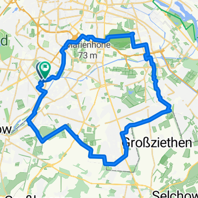
A cycling route starting in Lichterfelde, State of Berlin, Germany.
Overview
About this route
Berlin: Lichterfelde - Flughafen Tempelhof
- -:--
- Duration
- 10.1 km
- Distance
- 37 m
- Ascent
- 33 m
- Descent
- ---
- Avg. speed
- ---
- Max. altitude
Route quality
Waytypes & surfaces along the route
Waytypes
Path
4.4 km
(44 %)
Quiet road
2.8 km
(28 %)
Surfaces
Paved
7.2 km
(71 %)
Unpaved
1.4 km
(14 %)
Asphalt
7.1 km
(70 %)
Gravel
1.1 km
(11 %)
Continue with Bikemap
Use, edit, or download this cycling route
You would like to ride B-908: LIF - THF or customize it for your own trip? Here is what you can do with this Bikemap route:
Free features
- Save this route as favorite or in collections
- Copy & plan your own version of this route
- Sync your route with Garmin or Wahoo
Premium features
Free trial for 3 days, or one-time payment. More about Bikemap Premium.
- Navigate this route on iOS & Android
- Export a GPX / KML file of this route
- Create your custom printout (try it for free)
- Download this route for offline navigation
Discover more Premium features.
Get Bikemap PremiumFrom our community
Other popular routes starting in Lichterfelde
 VELOTHON Berlin 2011 >>Brandenburg-Schleife <<
- Distance
- 70.6 km
- Ascent
- 68 m
- Descent
- 70 m
- Location
- Lichterfelde, State of Berlin, Germany
 Rundtour 1
- Distance
- 43.6 km
- Ascent
- 130 m
- Descent
- 132 m
- Location
- Lichterfelde, State of Berlin, Germany
 Rund um Schönefeld
- Distance
- 83.2 km
- Ascent
- 88 m
- Descent
- 91 m
- Location
- Lichterfelde, State of Berlin, Germany
 Route in Berlin
- Distance
- 32.4 km
- Ascent
- 134 m
- Descent
- 139 m
- Location
- Lichterfelde, State of Berlin, Germany
 Lange Radrunde nach Rangsdorf Seehotel
- Distance
- 51.6 km
- Ascent
- 84 m
- Descent
- 84 m
- Location
- Lichterfelde, State of Berlin, Germany
 RTF Umland 70 km
- Distance
- 72 km
- Ascent
- 128 m
- Descent
- 125 m
- Location
- Lichterfelde, State of Berlin, Germany
 Lange Ausfahrt durch Potsdam bis Werder
- Distance
- 70.8 km
- Ascent
- 119 m
- Descent
- 127 m
- Location
- Lichterfelde, State of Berlin, Germany
 MTB-Runde Teltowkanal, Wannsee, Grunewald
- Distance
- 59.3 km
- Ascent
- 244 m
- Descent
- 243 m
- Location
- Lichterfelde, State of Berlin, Germany
Open it in the app