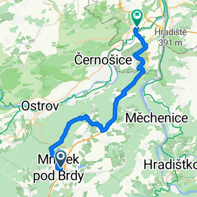
Brdskými lesy s dětským vozíkem
- 26.2 km
- 455 m
- 460 m
- Mníšek pod Brdy, Central Bohemia, Czechia
A cycling route starting in Mníšek pod Brdy, Central Bohemia, Czechia.
Overview
Kocába – a 45 km long river that entered the history of camping immediately after World War I, when it began to be visited by lovers of the Wild West, who nicknamed Kocába the Snake River. From the 1930s onward, hundreds of cabins and old camping settlements such as Ascalona, Dashwood, Kansas, Loussiana, etc., animated the rocky canyon. On this route, you will pass through a large part of the most beautiful section of Kocába, located between Nový Knín and Štěchovice.
A small route guide:
From Mníšek, follow the blue hiking trail along the forest path or the asphalt cycling route no. 8130 towards Chouzavá. Along the way, you will pass the excursion restaurant Malá Sv. Hora. It was formerly a pilgrimage site. There stands the Chapel of the Visitation of the Virgin Mary from 1809–1810 and a baroque wayside shrine. From here, continue on the green cycling route to Chouzavá. Here, turn right and take the yellow hiking trail to Voznice. In the village square by the pond, a pleasant restaurant with an outdoor terrace awaits you. If you prefer refreshments from your own supplies, continue a little further on the yellow hiking trail until you reach Králova stolice. On a small hill, in the middle of an 18th-century game reserve, stands a gazebo from which six roads radiate. The yellow hiking trail will safely lead you out of this labyrinth of paths towards Stará Huť. The name of this settlement may derive from an iron ore processing plant that operated here from 1650 until 1926, when it was closed. A little beyond the village, along cycling route no. 308 (blue hiking trail), you will arrive at the Strž pond. There is a natural bathing area, and under the pond dam stands an Empire-style house serving as a monument to Karel Čapek. The writer spent the last three years of his life here. The exhibition is also dedicated to his wife, actress and writer Olga Scheinpflugová. A separate exhibit in the house's attic features journalist and writer Ferdinand Peroutka. Continue on cycling route no. 308 (blue hiking trail) along forest paths until you reach an asphalt road. Turn left on it, and after about 3 km, you will arrive at Nový Knín. In Nový Knín, you will find many landmarks. On the square stand baroque houses and an Empire-style fountain from 1792, the two-story town hall no. 1 dates from the 17th century. The mint no. 47 from 1801 today serves as a museum of gold mining and processing around Nový Knín and as a city museum. The next section of the route will be indicated by the green hiking trail, which will take you just after Knín into picturesque corners of the Kocába river. The route may be technically demanding for some. No hills await you here, but the path is sometimes narrow and crosses Kocába several times on natural footbridges. It is definitely worth it. Civilization will briefly remind you during the passage through Velká and Malá Lečice, but you will then immerse yourself again in the Kocába valley. At the crossroads by Fafkova mill, you will say goodbye to Kocába and turn left on the blue hiking trail towards Bratřínov. However, if you still have enough strength and want to accompany Kocába to its confluence with the Vltava in Štěchovice (about 6 km more), you will find old camping settlements whose names recall the Wild West. These are complemented by towering rocky cliffs on the slopes of Kocába. The round trip will certainly not be regretted. From Fafkova mill, the blue hiking trail will lead you through Bratřínov to the Svatý Václav crossroads. There at the forest road junction stands a 1938 monument with an image of Saint Wenceslas. The back of the monument bears the inscription: This monument stands in the middle of forests which in 1908 Prince Josef Colloredo-Mansfeld donated to the sanatorium Na Pleši. It was erected in 1938 by Associate Professor MUDr. Svatopluk Basař in eternal memory of the patron. From this crossroads, the common route of the blue and green cycling trails leads back to Mníšek pod Brdy.
created this 16 years ago
Route quality
Track
20.3 km
49 %
Quiet road
10.4 km
25 %
Paved
6.6 km
(16 %)
Unpaved
19.1 km
(46 %)
Gravel
8.7 km
21 %
Unpaved (undefined)
7.1 km
17 %
Route highlights


Muzeum K.Čapka

Nový Knín


Continue with Bikemap
You would like to ride Hadí řekou - údolím Kocáby or customize it for your own trip? Here is what you can do with this Bikemap route:
Free trial for 3 days, or one-time payment. More about Bikemap Premium.
Discover more Premium features.
Get Bikemap PremiumFrom our community
Open it in the app