
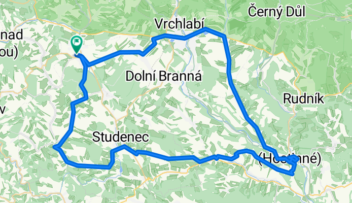
07 - Jilemnice LOP - Dolní Kalná
A cycling route starting in Jilemnice, Liberecký kraj, Czechia.
Overview
About this route
čistý čas 2:56
- -:--
- Duration
- 57.5 km
- Distance
- 473 m
- Ascent
- 476 m
- Descent
- ---
- Avg. speed
- ---
- Max. altitude

Route photos

Route quality
Waytypes & surfaces along the route
Waytypes
Road
37.4 km
(65 %)
Track
6.9 km
(12 %)
Surfaces
Paved
5.2 km
(9 %)
Unpaved
4.6 km
(8 %)
Asphalt
4.6 km
(8 %)
Gravel
3.5 km
(6 %)
Continue with Bikemap
Use, edit, or download this cycling route
You would like to ride 07 - Jilemnice LOP - Dolní Kalná or customize it for your own trip? Here is what you can do with this Bikemap route:
Free features
- Save this route as favorite or in collections
- Copy & plan your own version of this route
- Sync your route with Garmin or Wahoo
Premium features
Free trial for 3 days, or one-time payment. More about Bikemap Premium.
- Navigate this route on iOS & Android
- Export a GPX / KML file of this route
- Create your custom printout (try it for free)
- Download this route for offline navigation
Discover more Premium features.
Get Bikemap PremiumFrom our community
Other popular routes starting in Jilemnice
 11 - Jilemnice LOP - Žalí a ČS. Aspen
- Distance
- 55.9 km
- Ascent
- 983 m
- Descent
- 983 m
- Location
- Jilemnice, Liberecký kraj, Czechia
 2015-08-01 Riesengebirge Modre Sedlo+Spindlerpass
- Distance
- 102.3 km
- Ascent
- 1,833 m
- Descent
- 1,835 m
- Location
- Jilemnice, Liberecký kraj, Czechia
 07 - Jilemnice LOP - Dolní Kalná
- Distance
- 57.5 km
- Ascent
- 473 m
- Descent
- 476 m
- Location
- Jilemnice, Liberecký kraj, Czechia
 12 - Jilemnice LOP - Špindlerovka
- Distance
- 75.2 km
- Ascent
- 1,171 m
- Descent
- 1,171 m
- Location
- Jilemnice, Liberecký kraj, Czechia
 10 - Jilemnice LOP - Černá h. a Luční b.
- Distance
- 84.5 km
- Ascent
- 1,580 m
- Descent
- 1,580 m
- Location
- Jilemnice, Liberecký kraj, Czechia
 04 - Jilemnice LOP . Vrbatova bouda
- Distance
- 70.6 km
- Ascent
- 1,256 m
- Descent
- 1,256 m
- Location
- Jilemnice, Liberecký kraj, Czechia
 08 - Jilemnice LOP - Dvoračky
- Distance
- 58.3 km
- Ascent
- 1,263 m
- Descent
- 1,262 m
- Location
- Jilemnice, Liberecký kraj, Czechia
 13 - Jilemnice LOP - okolo Jilemnice
- Distance
- 33.6 km
- Ascent
- 392 m
- Descent
- 391 m
- Location
- Jilemnice, Liberecký kraj, Czechia
Open it in the app