

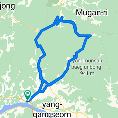
대곡치이사미
A cycling route starting in Yangp'yŏng, Gyeonggi-do, South Korea.
Overview
About this route
- -:--
- Duration
- 117.5 km
- Distance
- 1,320 m
- Ascent
- 1,320 m
- Descent
- ---
- Avg. speed
- ---
- Max. altitude
Route quality
Waytypes & surfaces along the route
Waytypes
Busy road
51.8 km
(44 %)
Road
48.3 km
(41 %)
Surfaces
Paved
5.7 km
(5 %)
Unpaved
0 km
(<1 %)
Concrete
5.4 km
(5 %)
Paved (undefined)
0.2 km
(<1 %)
Route highlights
Points of interest along the route
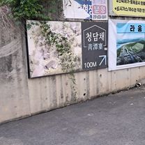
Point of interest after 13.4 km
오른쪽
Continue with Bikemap
Use, edit, or download this cycling route
You would like to ride 대곡치이사미 or customize it for your own trip? Here is what you can do with this Bikemap route:
Free features
- Save this route as favorite or in collections
- Copy & plan your own version of this route
- Split it into stages to create a multi-day tour
- Sync your route with Garmin or Wahoo
Premium features
Free trial for 3 days, or one-time payment. More about Bikemap Premium.
- Navigate this route on iOS & Android
- Export a GPX / KML file of this route
- Create your custom printout (try it for free)
- Download this route for offline navigation
Discover more Premium features.
Get Bikemap PremiumFrom our community
Other popular routes starting in Yangp'yŏng
 대신면, 여주시에서 천서리, 여주시까지
- Distance
- 63.3 km
- Ascent
- 300 m
- Descent
- 298 m
- Location
- Yangp'yŏng, Gyeonggi-do, South Korea
 Day#2
Day#2- Distance
- 61.5 km
- Ascent
- 703 m
- Descent
- 710 m
- Location
- Yangp'yŏng, Gyeonggi-do, South Korea
 양평군에서 양평군까지
- Distance
- 30.4 km
- Ascent
- 342 m
- Descent
- 345 m
- Location
- Yangp'yŏng, Gyeonggi-do, South Korea
 양평-양수역-벗고개-서후고개-문호리-문안고개-외서면-남이섬 86km 1030m
- Distance
- 86.1 km
- Ascent
- 642 m
- Descent
- 597 m
- Location
- Yangp'yŏng, Gyeonggi-do, South Korea
 asin-seoljimae-yumyeong loop
- Distance
- 63.7 km
- Ascent
- 1,885 m
- Descent
- 1,890 m
- Location
- Yangp'yŏng, Gyeonggi-do, South Korea
 양평-17화전로고개-43백양치(홍천)-62고드래미-72지장구고개-83혈동고개.덕만이고개-94종자터널-110말굽고개-112홍천
- Distance
- 112.4 km
- Ascent
- 2,242 m
- Descent
- 2,153 m
- Location
- Yangp'yŏng, Gyeonggi-do, South Korea
 양서면 496-8 ~ 조안면 285-6
- Distance
- 20.4 km
- Ascent
- 162 m
- Descent
- 187 m
- Location
- Yangp'yŏng, Gyeonggi-do, South Korea
 JeePyeong - 88km
- Distance
- 88.5 km
- Ascent
- 849 m
- Descent
- 850 m
- Location
- Yangp'yŏng, Gyeonggi-do, South Korea
Open it in the app