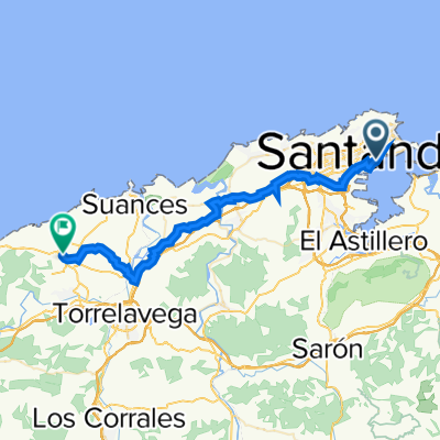
camino de santiago
A cycling route starting in Santander, Cantabria, Spain.
Overview
About this route
walking route along the Camino del Norte: Santander - Santiago de Compostela - Finisterre
- -:--
- Duration
- 688.8 km
- Distance
- 2,148 m
- Ascent
- 2,067 m
- Descent
- ---
- Avg. speed
- ---
- Max. altitude
Route highlights
Points of interest along the route
Point of interest after 0.2 km
start
Point of interest after 17.8 km
pierwszy nocleg - Mogro, plaza na dziko
Point of interest after 49 km
drugi nocleg - Cobreces, albergue
Point of interest after 87.1 km
trzeci nocleg - Unquera, na dziko
Point of interest after 120.5 km
czwarty nocleg - Celorio, u Santiago
Point of interest after 148.3 km
piaty nocleg - Ribadesella, youth hostel
Point of interest after 182.7 km
szosty nocleg - Sebrayo, albergue
Point of interest after 221.9 km
siodmy nocleg - Gijon, plaza
Point of interest after 253.9 km
osmy nocleg - Aviles, albergue
Point of interest after 286.5 km
dziewiaty nocleg - Soto de Luina, albergue
Point of interest after 319.9 km
dziesiaty nocleg - Cadavedo, albergue
Point of interest after 360.1 km
jedenasty nocleg - Navia, dziko
Point of interest after 381.5 km
dwunasty nocleg - Tapia, albergue
Point of interest after 425.2 km
trzynasty nocleg - Lourenza, sala
Point of interest after 456.1 km
czternasty nocleg - Abadin, sala
Point of interest after 498.6 km
pietnasty nocleg - Baamonde, sala
Point of interest after 540.2 km
szesnasty nocleg - Sobrado, klasztor
Point of interest after 559.4 km
siedemnasty nocleg - Arzua, albergue
Point of interest after 595.2 km
dziewietnasty nocleg - Monte do Gozo, albergue
Point of interest after 601 km
dwudziesty nocleg - Santiago, albergue
Point of interest after 630.8 km
dwudziesty pierwszy nocleg - pole, dziko
Point of interest after 656.4 km
dwudziesty drugi nocleg - Oliveiroa, albergue
Point of interest after 686.2 km
dwudziesty trzeci nocleg - Fisterre, albergue
Point of interest after 688.8 km
Finisterre - koniec
Continue with Bikemap
Use, edit, or download this cycling route
You would like to ride camino de santiago or customize it for your own trip? Here is what you can do with this Bikemap route:
Free features
- Save this route as favorite or in collections
- Copy & plan your own version of this route
- Split it into stages to create a multi-day tour
- Sync your route with Garmin or Wahoo
Premium features
Free trial for 3 days, or one-time payment. More about Bikemap Premium.
- Navigate this route on iOS & Android
- Export a GPX / KML file of this route
- Create your custom printout (try it for free)
- Download this route for offline navigation
Discover more Premium features.
Get Bikemap PremiumFrom our community
Other popular routes starting in Santander
 bilbao to rabat
- Distance
- 1,386.5 km
- Ascent
- 2,943 m
- Descent
- 2,929 m
- Location
- Santander, Cantabria, Spain
 Azoños-Escobedo-P.Arce-Mortera y alrededores de Santander
- Distance
- 45.6 km
- Ascent
- 368 m
- Descent
- 368 m
- Location
- Santander, Cantabria, Spain
 A Pedreña
- Distance
- 45.9 km
- Ascent
- 403 m
- Descent
- 406 m
- Location
- Santander, Cantabria, Spain
 Santander - Ribadesella
- Distance
- 136.3 km
- Ascent
- 784 m
- Descent
- 771 m
- Location
- Santander, Cantabria, Spain
 Santander-Cacicedo-Escobedo-PuenteArce-Polanco-Vioño-Oruña-Boo-Liencres-Santander
- Distance
- 71.7 km
- Ascent
- 556 m
- Descent
- 555 m
- Location
- Santander, Cantabria, Spain
 al faro por la Madalena 12sept
- Distance
- 19.3 km
- Ascent
- 203 m
- Descent
- 205 m
- Location
- Santander, Cantabria, Spain
 Costa de Santander
- Distance
- 41.9 km
- Ascent
- 337 m
- Descent
- 337 m
- Location
- Santander, Cantabria, Spain
 Stage 1
- Distance
- 36.1 km
- Ascent
- 308 m
- Descent
- 205 m
- Location
- Santander, Cantabria, Spain
Open it in the app


