

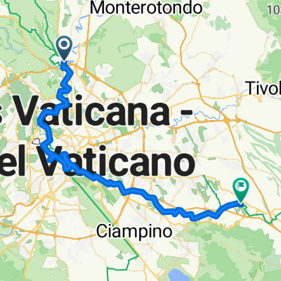
E-14.Tiber-Radweg
A cycling route starting in Monte Caminetto, Lazio, Italy.
Overview
About this route
TEASI track
- -:--
- Duration
- 15.5 km
- Distance
- 67 m
- Ascent
- 61 m
- Descent
- ---
- Avg. speed
- ---
- Max. altitude
Continue with Bikemap
Use, edit, or download this cycling route
You would like to ride E-14.Tiber-Radweg or customize it for your own trip? Here is what you can do with this Bikemap route:
Free features
- Save this route as favorite or in collections
- Copy & plan your own version of this route
- Sync your route with Garmin or Wahoo
Premium features
Free trial for 3 days, or one-time payment. More about Bikemap Premium.
- Navigate this route on iOS & Android
- Export a GPX / KML file of this route
- Create your custom printout (try it for free)
- Download this route for offline navigation
Discover more Premium features.
Get Bikemap PremiumFrom our community
Other popular routes starting in Monte Caminetto
 Parco di Veio
- Distance
- 29.4 km
- Ascent
- 300 m
- Descent
- 301 m
- Location
- Monte Caminetto, Lazio, Italy
 roma - borghetto
- Distance
- 62.3 km
- Ascent
- 594 m
- Descent
- 568 m
- Location
- Monte Caminetto, Lazio, Italy
 Quick ride from Roma to Prima Porta
- Distance
- 3.8 km
- Ascent
- 50 m
- Descent
- 100 m
- Location
- Monte Caminetto, Lazio, Italy
 Castel Giubileo Ostia Antica
- Distance
- 53.4 km
- Ascent
- 98 m
- Descent
- 115 m
- Location
- Monte Caminetto, Lazio, Italy
 Italie 21 rome ville
- Distance
- 33.2 km
- Ascent
- 158 m
- Descent
- 154 m
- Location
- Monte Caminetto, Lazio, Italy
 Ciclabile Lungo Tevere Labaro - Fiumicino al mare
- Distance
- 72.2 km
- Ascent
- 221 m
- Descent
- 244 m
- Location
- Monte Caminetto, Lazio, Italy
 Monte Caminetto - Colonna
- Distance
- 60 km
- Ascent
- 668 m
- Descent
- 438 m
- Location
- Monte Caminetto, Lazio, Italy
 E-14.Tiber-Radweg
- Distance
- 15.5 km
- Ascent
- 67 m
- Descent
- 61 m
- Location
- Monte Caminetto, Lazio, Italy
Open it in the app