

Cerro del Portugues. Ruta por detras del Chantre.
A cycling route starting in Cuenca, Castille-La Mancha, Spain.
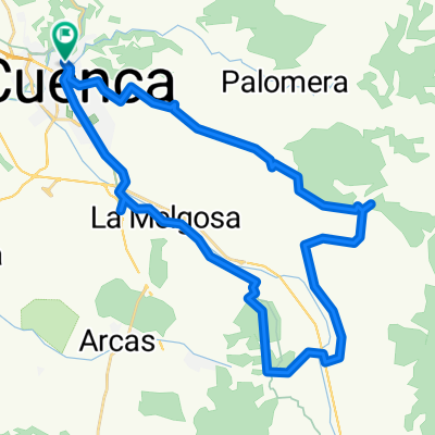
Overview
About this route
A route very close to Cuenca, easy and enjoyable.
- -:--
- Duration
- 29.2 km
- Distance
- 534 m
- Ascent
- 534 m
- Descent
- ---
- Avg. speed
- ---
- Max. altitude
Route highlights
Points of interest along the route
Point of interest after 3.8 km
Cerro de las Antenas o de San Cristobal
Photo after 5.7 km
Fuente de Martín Alhaja
Photo after 10 km
Cerro del Portugues
Photo after 10.5 km
Corral
Point of interest after 13.2 km
Comienzo de la subida de la senda de la Losilla
Point of interest after 18.8 km
Puente de Valdecabras
Point of interest after 19.8 km
Subida al Cerro de las Antenas o Cerro de San Cristobal
Continue with Bikemap
Use, edit, or download this cycling route
You would like to ride Cerro del Portugues. Ruta por detras del Chantre. or customize it for your own trip? Here is what you can do with this Bikemap route:
Free features
- Save this route as favorite or in collections
- Copy & plan your own version of this route
- Sync your route with Garmin or Wahoo
Premium features
Free trial for 3 days, or one-time payment. More about Bikemap Premium.
- Navigate this route on iOS & Android
- Export a GPX / KML file of this route
- Create your custom printout (try it for free)
- Download this route for offline navigation
Discover more Premium features.
Get Bikemap PremiumFrom our community
Other popular routes starting in Cuenca
 Vallejo de la Cueva del Fraile
- Distance
- 41.9 km
- Ascent
- 446 m
- Descent
- 449 m
- Location
- Cuenca, Castille-La Mancha, Spain
 Lagunas de Fuentes
- Distance
- 40.5 km
- Ascent
- 318 m
- Descent
- 318 m
- Location
- Cuenca, Castille-La Mancha, Spain
 El Terminillo
- Distance
- 12.8 km
- Ascent
- 37 m
- Descent
- 38 m
- Location
- Cuenca, Castille-La Mancha, Spain
 Arroyo Bonilla
- Distance
- 25.9 km
- Ascent
- 604 m
- Descent
- 604 m
- Location
- Cuenca, Castille-La Mancha, Spain
 Mirador de el Ceño
- Distance
- 43.9 km
- Ascent
- 483 m
- Descent
- 483 m
- Location
- Cuenca, Castille-La Mancha, Spain
 Senda del Barranco de la Zorra o senda de la carrera.
- Distance
- 24.1 km
- Ascent
- 448 m
- Descent
- 448 m
- Location
- Cuenca, Castille-La Mancha, Spain
 Alto de la Nava
- Distance
- 46.3 km
- Ascent
- 625 m
- Descent
- 624 m
- Location
- Cuenca, Castille-La Mancha, Spain
 Las Zomas. La Mota
- Distance
- 42.6 km
- Ascent
- 517 m
- Descent
- 516 m
- Location
- Cuenca, Castille-La Mancha, Spain
Open it in the app