

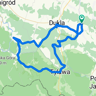
Rymanów - Słowacja
A cycling route starting in Iwonicz-Zdrój, Subcarpathian Voivodeship, Poland.
Overview
About this route
UWAGA!!!
Odcinek Lipowiec-Certizne praktycznie nieprzejezdny dla szosówek - tylko Trekking/MTB.
Pozostała trasa idealna szosa.
- -:--
- Duration
- 96.1 km
- Distance
- 912 m
- Ascent
- 914 m
- Descent
- ---
- Avg. speed
- ---
- Max. altitude
Route photos


Route quality
Waytypes & surfaces along the route
Waytypes
Busy road
81.8 km
(85 %)
Quiet road
10.6 km
(11 %)
Surfaces
Paved
77.9 km
(81 %)
Unpaved
7.2 km
(7 %)
Asphalt
77.8 km
(81 %)
Gravel
7.2 km
(7 %)
Continue with Bikemap
Use, edit, or download this cycling route
You would like to ride Rymanów - Słowacja or customize it for your own trip? Here is what you can do with this Bikemap route:
Free features
- Save this route as favorite or in collections
- Copy & plan your own version of this route
- Split it into stages to create a multi-day tour
- Sync your route with Garmin or Wahoo
Premium features
Free trial for 3 days, or one-time payment. More about Bikemap Premium.
- Navigate this route on iOS & Android
- Export a GPX / KML file of this route
- Create your custom printout (try it for free)
- Download this route for offline navigation
Discover more Premium features.
Get Bikemap PremiumFrom our community
Other popular routes starting in Iwonicz-Zdrój
 Iwonicz Rymanów
- Distance
- 24.8 km
- Ascent
- 365 m
- Descent
- 366 m
- Location
- Iwonicz-Zdrój, Subcarpathian Voivodeship, Poland
 Kamień nad Jaśliskami
- Distance
- 69.1 km
- Ascent
- 1,172 m
- Descent
- 1,172 m
- Location
- Iwonicz-Zdrój, Subcarpathian Voivodeship, Poland
 3.Iwonicz-Komancza
- Distance
- 45.6 km
- Ascent
- 1,535 m
- Descent
- 1,935 m
- Location
- Iwonicz-Zdrój, Subcarpathian Voivodeship, Poland
 trasa xyz
- Distance
- 56.2 km
- Ascent
- 1,340 m
- Descent
- 1,340 m
- Location
- Iwonicz-Zdrój, Subcarpathian Voivodeship, Poland
 Trasa z Iwonickie edycji Cyklokarpat 2011 + Cergowa
- Distance
- 34.5 km
- Ascent
- 924 m
- Descent
- 924 m
- Location
- Iwonicz-Zdrój, Subcarpathian Voivodeship, Poland
 Iwonicz Zdroj-Rymanow Zdroj-osemka-47 km
- Distance
- 46.3 km
- Ascent
- 541 m
- Descent
- 541 m
- Location
- Iwonicz-Zdrój, Subcarpathian Voivodeship, Poland
 Med++
Med++- Distance
- 120.4 km
- Ascent
- 713 m
- Descent
- 716 m
- Location
- Iwonicz-Zdrój, Subcarpathian Voivodeship, Poland
 Iwonicz-Rymanów-Komańcza-Nowotaniec-Sieniawa-Iwonicz
- Distance
- 109 km
- Ascent
- 737 m
- Descent
- 737 m
- Location
- Iwonicz-Zdrój, Subcarpathian Voivodeship, Poland
Open it in the app