

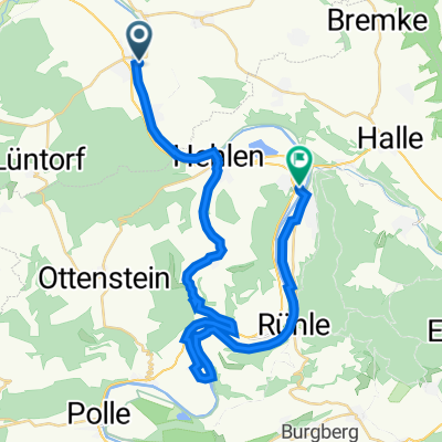
20160918_133657.gpx
A cycling route starting in Hehlen, Lower Saxony, Germany.
Overview
About this route
Hier meine Mountainbikestrecke quer durch den Vogler.
Ein Teilstück sind wir immer wieder auf der offiziellen MTB-Strecke gefahren, die auch gut ausgeschildert ist. Außer an den Stellen an denen die Beschilderung fehlt, und vor allem wenn sie uns versucht hat auf eine Landstraße zu führen. Deswegen wird die Strecke an manchen Stellen wirklich anspruchsvoll.
Trotzdem hatten wir mit unseren Focus Rädern viel Spaß. Der Akku war nach 60km leer und unsere Kondition auch.
Viel Spaß beim abfahren.
P.S. Der Track endet an einer sehr guten Gastronomie. Dort haben wir ganz bequem unsere verbrannte Energie wieder aufgetankt. ;-)
- -:--
- Duration
- 50 km
- Distance
- 919 m
- Ascent
- 920 m
- Descent
- ---
- Avg. speed
- ---
- Max. altitude
Route quality
Waytypes & surfaces along the route
Waytypes
Track
33.5 km
(67 %)
Quiet road
6 km
(12 %)
Surfaces
Paved
14 km
(28 %)
Unpaved
27 km
(54 %)
Ground
13.5 km
(27 %)
Asphalt
12.5 km
(25 %)
Continue with Bikemap
Use, edit, or download this cycling route
You would like to ride 20160918_133657.gpx or customize it for your own trip? Here is what you can do with this Bikemap route:
Free features
- Save this route as favorite or in collections
- Copy & plan your own version of this route
- Sync your route with Garmin or Wahoo
Premium features
Free trial for 3 days, or one-time payment. More about Bikemap Premium.
- Navigate this route on iOS & Android
- Export a GPX / KML file of this route
- Create your custom printout (try it for free)
- Download this route for offline navigation
Discover more Premium features.
Get Bikemap PremiumFrom our community
Other popular routes starting in Hehlen
 Grohnde, Emmerthal nach Kniepstraße 9A, Hameln
- Distance
- 5.5 km
- Ascent
- 24 m
- Descent
- 23 m
- Location
- Hehlen, Lower Saxony, Germany
 WESER-Radweg Tag 2
- Distance
- 68.5 km
- Ascent
- 60 m
- Descent
- 79 m
- Location
- Hehlen, Lower Saxony, Germany
 Hajen Niependoor nach Straße Ohne Straßennamen
- Distance
- 25.4 km
- Ascent
- 284 m
- Descent
- 142 m
- Location
- Hehlen, Lower Saxony, Germany
 Grohnde, Emmerthal nach Kniepstraße 9, Hameln
- Distance
- 5 km
- Ascent
- 31 m
- Descent
- 20 m
- Location
- Hehlen, Lower Saxony, Germany
 20160918_133657.gpx
- Distance
- 50 km
- Ascent
- 919 m
- Descent
- 920 m
- Location
- Hehlen, Lower Saxony, Germany
 Von Grohnde über den Berg und an der Weser zurück
- Distance
- 30.7 km
- Ascent
- 284 m
- Descent
- 280 m
- Location
- Hehlen, Lower Saxony, Germany
 Grohnde, Emmerthal nach Kniepstraße 9, Hameln
- Distance
- 5.2 km
- Ascent
- 15 m
- Descent
- 19 m
- Location
- Hehlen, Lower Saxony, Germany
 Brevörde - Sarstedt
- Distance
- 64 km
- Ascent
- 247 m
- Descent
- 264 m
- Location
- Hehlen, Lower Saxony, Germany
Open it in the app