

Col de Cenise via Lac Bétin
A cycling route starting in Ayse, Auvergne-Rhône-Alpes, France.
Overview
About this route
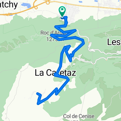
Fantastic climb in north Alps. (This is not Col du Mont-Cenis). The detour to the lake required some pushing and the descent down to the road to Cenise was pure hiking. But fun. Cenise itself is paved to 1570 metres then gravel to 1724 metres
- -:--
- Duration
- 44.8 km
- Distance
- 1,641 m
- Ascent
- 1,641 m
- Descent
- ---
- Avg. speed
- ---
- Max. altitude

Route photos

Route highlights
Points of interest along the route
Point of interest after 15.5 km
Lac Bétin - 1460 metres
Point of interest after 25 km
Col de Cenise - 1724 metres
Continue with Bikemap
Use, edit, or download this cycling route
You would like to ride Col de Cenise via Lac Bétin or customize it for your own trip? Here is what you can do with this Bikemap route:
Free features
- Save this route as favorite or in collections
- Copy & plan your own version of this route
- Sync your route with Garmin or Wahoo
Premium features
Free trial for 3 days, or one-time payment. More about Bikemap Premium.
- Navigate this route on iOS & Android
- Export a GPX / KML file of this route
- Create your custom printout (try it for free)
- Download this route for offline navigation
Discover more Premium features.
Get Bikemap PremiumFrom our community
Other popular routes starting in Ayse
 L_etape_du tour_Ayse-Marignier-LaRamaz-JouxPlaines_Morzine_LeGets_Ayse
- Distance
- 111.2 km
- Ascent
- 2,431 m
- Descent
- 2,441 m
- Location
- Ayse, Auvergne-Rhône-Alpes, France
 col les fleuries
- Distance
- 56.1 km
- Ascent
- 690 m
- Descent
- 688 m
- Location
- Ayse, Auvergne-Rhône-Alpes, France
 Col de Solaison
- Distance
- 24 km
- Ascent
- 1,362 m
- Descent
- 1,301 m
- Location
- Ayse, Auvergne-Rhône-Alpes, France
 Col de Solaison
- Distance
- 24.1 km
- Ascent
- 1,045 m
- Descent
- 1,045 m
- Location
- Ayse, Auvergne-Rhône-Alpes, France
 Grand Bernard
- Distance
- 58.5 km
- Ascent
- 1,165 m
- Descent
- 1,169 m
- Location
- Ayse, Auvergne-Rhône-Alpes, France
 Ue, duex trois... Solaison!
- Distance
- 54 km
- Ascent
- 2,130 m
- Descent
- 1,074 m
- Location
- Ayse, Auvergne-Rhône-Alpes, France
 Glieres Raid
- Distance
- 106.5 km
- Ascent
- 2,801 m
- Descent
- 2,803 m
- Location
- Ayse, Auvergne-Rhône-Alpes, France
 Col de Solaizon
- Distance
- 47.1 km
- Ascent
- 1,740 m
- Descent
- 1,579 m
- Location
- Ayse, Auvergne-Rhône-Alpes, France
Open it in the app