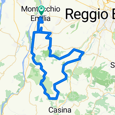
Scurano da Valtoccana - Sella Lodrignano -Cedogno
A cycling route starting in Montecchio Emilia, Emilia-Romagna, Italy.
Overview
About this route
Classic route with good mileage for the end of the season. From Langhirano, one takes on the 'usual' Valtoccana before climbing to Scurano. From here, one goes to the Sella di Lodrignano and then back down towards Cedogno; crossing the Enza and then home from Ciano.
If desired, at the end of the Valtoccana, one can avoid the climb of the Sasso towards Scurano by turning left towards Lupazzano, where there is a double alternative: either descend towards Cedogno just before Lupazzano on the right (challenging descent) and return via Ciano. Or one can reach the intersection of the 4 roads after Lupazzano and descend to Traversetolo via the 'corkscrew' or Valtermina.
- -:--
- Duration
- 84.9 km
- Distance
- 2,034 m
- Ascent
- 1,895 m
- Descent
- ---
- Avg. speed
- 733 m
- Max. altitude
Route quality
Waytypes & surfaces along the route
Waytypes
Road
24.6 km
(29 %)
Quiet road
5.9 km
(7 %)
Surfaces
Paved
23.8 km
(28 %)
Unpaved
5.1 km
(6 %)
Asphalt
23.8 km
(28 %)
Ground
3.4 km
(4 %)
Continue with Bikemap
Use, edit, or download this cycling route
You would like to ride Scurano da Valtoccana - Sella Lodrignano -Cedogno or customize it for your own trip? Here is what you can do with this Bikemap route:
Free features
- Save this route as favorite or in collections
- Copy & plan your own version of this route
- Split it into stages to create a multi-day tour
- Sync your route with Garmin or Wahoo
Premium features
Free trial for 3 days, or one-time payment. More about Bikemap Premium.
- Navigate this route on iOS & Android
- Export a GPX / KML file of this route
- Create your custom printout (try it for free)
- Download this route for offline navigation
Discover more Premium features.
Get Bikemap PremiumFrom our community
Other popular routes starting in Montecchio Emilia
- LESIGNANO PALMIA PIANTONIA
- Distance
- 110.4 km
- Ascent
- 1,034 m
- Descent
- 1,033 m
- Location
- Montecchio Emilia, Emilia-Romagna, Italy
- felina villaprara carpineti casina
- Distance
- 89.8 km
- Ascent
- 1,476 m
- Descent
- 1,476 m
- Location
- Montecchio Emilia, Emilia-Romagna, Italy
- Trinità - Gombio - Cast. Monti
- Distance
- 86.5 km
- Ascent
- 2,601 m
- Descent
- 2,466 m
- Location
- Montecchio Emilia, Emilia-Romagna, Italy
- Famiglie in bici, anello Montecchio -San Polo -Cerezzola
- Distance
- 36.8 km
- Ascent
- 162 m
- Descent
- 160 m
- Location
- Montecchio Emilia, Emilia-Romagna, Italy
- paderna-la stella -canossa
- Distance
- 62.9 km
- Ascent
- 718 m
- Descent
- 717 m
- Location
- Montecchio Emilia, Emilia-Romagna, Italy
- Montecchio Emilia - Casina
- Distance
- 65 km
- Ascent
- 701 m
- Descent
- 701 m
- Location
- Montecchio Emilia, Emilia-Romagna, Italy
- Bazzano-cedogno-sella lodrignano
- Distance
- 55.7 km
- Ascent
- 574 m
- Descent
- 572 m
- Location
- Montecchio Emilia, Emilia-Romagna, Italy
- Urzano -passo crocione - Stadirano - Valtermina
- Distance
- 60.6 km
- Ascent
- 1,066 m
- Descent
- 1,041 m
- Location
- Montecchio Emilia, Emilia-Romagna, Italy
Open it in the app