

da max - massa marittima
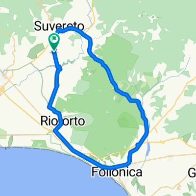
A cycling route starting in Suvereto, Tuscany, Italy.
Overview
About this route
wie überall in dieser gegend, wenig verkehr und schön zu fahren.
auf dem rückweg das mittagessen unbedingt in san lorenzo einplanen!
schlicht, einfach, gut.
- -:--
- Duration
- 72.7 km
- Distance
- 1,138 m
- Ascent
- 1,356 m
- Descent
- ---
- Avg. speed
- 417 m
- Max. altitude

Route quality
Waytypes & surfaces along the route
Waytypes
Quiet road
27.5 km
(38 %)
Road
22.5 km
(31 %)
Surfaces
Paved
43.8 km
(60 %)
Unpaved
5 km
(7 %)
Asphalt
43.8 km
(60 %)
Gravel
2.8 km
(4 %)
Continue with Bikemap
Use, edit, or download this cycling route
You would like to ride da max - massa marittima or customize it for your own trip? Here is what you can do with this Bikemap route:
Free features
- Save this route as favorite or in collections
- Copy & plan your own version of this route
- Sync your route with Garmin or Wahoo
Premium features
Free trial for 3 days, or one-time payment. More about Bikemap Premium.
- Navigate this route on iOS & Android
- Export a GPX / KML file of this route
- Create your custom printout (try it for free)
- Download this route for offline navigation
Discover more Premium features.
Get Bikemap PremiumFrom our community
Other popular routes starting in Suvereto
 Da Località San Michele 49, Suvereto a Località San Michele 49, Suvereto
- Distance
- 47.7 km
- Ascent
- 255 m
- Descent
- 268 m
- Location
- Suvereto, Tuscany, Italy
 Prata Montebamboli Massa
- Distance
- 63 km
- Ascent
- 741 m
- Descent
- 737 m
- Location
- Suvereto, Tuscany, Italy
 Tour Agliail
- Distance
- 32.8 km
- Ascent
- 413 m
- Descent
- 410 m
- Location
- Suvereto, Tuscany, Italy
 da max - massa marittima
- Distance
- 72.7 km
- Ascent
- 1,138 m
- Descent
- 1,356 m
- Location
- Suvereto, Tuscany, Italy
 Biancane geotermikus park (Massa Marittima)
- Distance
- 66.3 km
- Ascent
- 847 m
- Descent
- 846 m
- Location
- Suvereto, Tuscany, Italy
 Massa Marittima kör
- Distance
- 50 km
- Ascent
- 588 m
- Descent
- 591 m
- Location
- Suvereto, Tuscany, Italy
 suverto - monteverdi-sassetta- bellvedere"max"
- Distance
- 48.4 km
- Ascent
- 1,050 m
- Descent
- 1,111 m
- Location
- Suvereto, Tuscany, Italy
 Larderello és a Biancane nemzeti park
- Distance
- 75 km
- Ascent
- 1,058 m
- Descent
- 1,058 m
- Location
- Suvereto, Tuscany, Italy
Open it in the app