

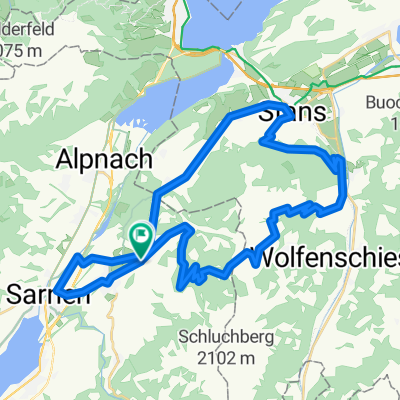
ÄCHERLIPASS, por Sand
A cycling route starting in Kerns, Canton of Obwalden, Switzerland.
Overview
About this route
Climb.
- -:--
- Duration
- 8.4 km
- Distance
- 876 m
- Ascent
- 0 m
- Descent
- ---
- Avg. speed
- ---
- Max. altitude

Route quality
Waytypes & surfaces along the route
Waytypes
Quiet road
8.4 km
(100 %)
Surfaces
Paved
4.4 km
(52 %)
Paved (undefined)
4.4 km
(52 %)
Undefined
4 km
(48 %)
Continue with Bikemap
Use, edit, or download this cycling route
You would like to ride ÄCHERLIPASS, por Sand or customize it for your own trip? Here is what you can do with this Bikemap route:
Free features
- Save this route as favorite or in collections
- Copy & plan your own version of this route
- Sync your route with Garmin or Wahoo
Premium features
Free trial for 3 days, or one-time payment. More about Bikemap Premium.
- Navigate this route on iOS & Android
- Export a GPX / KML file of this route
- Create your custom printout (try it for free)
- Download this route for offline navigation
Discover more Premium features.
Get Bikemap PremiumFrom our community
Other popular routes starting in Kerns
 Kerns-Zingel-Alpnach-Kerns
- Distance
- 19.3 km
- Ascent
- 459 m
- Descent
- 460 m
- Location
- Kerns, Canton of Obwalden, Switzerland
 ÄCHERLIPASS, por Sand
- Distance
- 8.4 km
- Ascent
- 876 m
- Descent
- 0 m
- Location
- Kerns, Canton of Obwalden, Switzerland
 Gemütliche Route in Kerns
- Distance
- 20.9 km
- Ascent
- 570 m
- Descent
- 578 m
- Location
- Kerns, Canton of Obwalden, Switzerland
 Swizerlands centre
- Distance
- 46.8 km
- Ascent
- 994 m
- Descent
- 1,075 m
- Location
- Kerns, Canton of Obwalden, Switzerland
 boro 1
- Distance
- 43.4 km
- Ascent
- 1,599 m
- Descent
- 1,642 m
- Location
- Kerns, Canton of Obwalden, Switzerland
 Kerns - Schwandi
- Distance
- 13.5 km
- Ascent
- 523 m
- Descent
- 522 m
- Location
- Kerns, Canton of Obwalden, Switzerland
 Kerns - Engelberg
- Distance
- 33.8 km
- Ascent
- 606 m
- Descent
- 185 m
- Location
- Kerns, Canton of Obwalden, Switzerland
 Kerns - Langnau i.E. (Etappe 3)
- Distance
- 63.5 km
- Ascent
- 1,516 m
- Descent
- 1,370 m
- Location
- Kerns, Canton of Obwalden, Switzerland
Open it in the app