

Oberessendorf Waldsee Aulendorf Saulgau
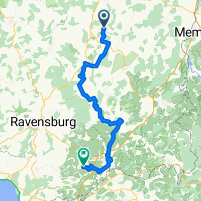
A cycling route starting in Eberhardzell, Baden-Wurttemberg, Germany.
Overview
About this route
Oberessendorf towards Waldsee / passing Volkertshaus Abetsweiler Gwigg Gaisbeuren Reute towards Aulendorf Zollenreute Münchenreute Steinenbach Ebersbach towards Saulgau 7-Mühlen-Tal Herberingen Binzwangen Waldhausen Altheim
- -:--
- Duration
- 80.1 km
- Distance
- 283 m
- Ascent
- 326 m
- Descent
- ---
- Avg. speed
- ---
- Max. altitude

Route quality
Waytypes & surfaces along the route
Waytypes
Quiet road
39.2 km
(49 %)
Road
21.6 km
(27 %)
Surfaces
Paved
37.6 km
(47 %)
Asphalt
36.8 km
(46 %)
Paved (undefined)
0.8 km
(1 %)
Undefined
42.4 km
(53 %)
Continue with Bikemap
Use, edit, or download this cycling route
You would like to ride Oberessendorf Waldsee Aulendorf Saulgau or customize it for your own trip? Here is what you can do with this Bikemap route:
Free features
- Save this route as favorite or in collections
- Copy & plan your own version of this route
- Split it into stages to create a multi-day tour
- Sync your route with Garmin or Wahoo
Premium features
Free trial for 3 days, or one-time payment. More about Bikemap Premium.
- Navigate this route on iOS & Android
- Export a GPX / KML file of this route
- Create your custom printout (try it for free)
- Download this route for offline navigation
Discover more Premium features.
Get Bikemap PremiumFrom our community
Other popular routes starting in Eberhardzell
 Pfingsten 2016 - Alpencross
- Distance
- 833.4 km
- Ascent
- 2,120 m
- Descent
- 2,593 m
- Location
- Eberhardzell, Baden-Wurttemberg, Germany
 Pfänder
- Distance
- 157.9 km
- Ascent
- 1,130 m
- Descent
- 1,131 m
- Location
- Eberhardzell, Baden-Wurttemberg, Germany
 Eberhardzell - Amtzell
- Distance
- 71.6 km
- Ascent
- 859 m
- Descent
- 880 m
- Location
- Eberhardzell, Baden-Wurttemberg, Germany
 Eberhardzell nach Biberach
- Distance
- 14.2 km
- Ascent
- 89 m
- Descent
- 166 m
- Location
- Eberhardzell, Baden-Wurttemberg, Germany
 Oberessendorf Waldsee Aulendorf Saulgau
- Distance
- 80.1 km
- Ascent
- 283 m
- Descent
- 326 m
- Location
- Eberhardzell, Baden-Wurttemberg, Germany
 Auf die Alb durchs Lautertal und zurück
- Distance
- 151.9 km
- Ascent
- 881 m
- Descent
- 881 m
- Location
- Eberhardzell, Baden-Wurttemberg, Germany
 Oberessendorfer Straße 10, Eberhardzell nach Wolpertsheim, Bad Waldsee
- Distance
- 16.9 km
- Ascent
- 134 m
- Descent
- 127 m
- Location
- Eberhardzell, Baden-Wurttemberg, Germany
 Rundfahrt Eberhardzell durchs Ländle
- Distance
- 31.7 km
- Ascent
- 181 m
- Descent
- 181 m
- Location
- Eberhardzell, Baden-Wurttemberg, Germany
Open it in the app