

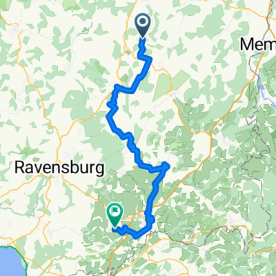
Oberessendorf Ringschnait Äpfingen O´stadion
A cycling route starting in Eberhardzell, Baden-Wurttemberg, Germany.
Overview
About this route
Oberessendorf towards Ochsenhausen towards Biberach Laupertshausen Äpfingen Schemmerberg Altheim Moosbeuren Oberstadion Grundsheim Sauggart Uigendorf Dietelhofen Möhringen Unlingen Eichenau Daugendorf Grüningen
- -:--
- Duration
- 76.1 km
- Distance
- 327 m
- Ascent
- 367 m
- Descent
- ---
- Avg. speed
- ---
- Max. altitude

Route quality
Waytypes & surfaces along the route
Waytypes
Road
41.1 km
(54 %)
Quiet road
16.7 km
(22 %)
Surfaces
Paved
48.7 km
(64 %)
Unpaved
5.3 km
(7 %)
Asphalt
47.9 km
(63 %)
Loose gravel
2.3 km
(3 %)
Continue with Bikemap
Use, edit, or download this cycling route
You would like to ride Oberessendorf Ringschnait Äpfingen O´stadion or customize it for your own trip? Here is what you can do with this Bikemap route:
Free features
- Save this route as favorite or in collections
- Copy & plan your own version of this route
- Sync your route with Garmin or Wahoo
Premium features
Free trial for 3 days, or one-time payment. More about Bikemap Premium.
- Navigate this route on iOS & Android
- Export a GPX / KML file of this route
- Create your custom printout (try it for free)
- Download this route for offline navigation
Discover more Premium features.
Get Bikemap PremiumFrom our community
Other popular routes starting in Eberhardzell
 Pfänder
- Distance
- 157.9 km
- Ascent
- 1,130 m
- Descent
- 1,131 m
- Location
- Eberhardzell, Baden-Wurttemberg, Germany
 Rundfahrt Eberhardzell durchs Ländle
- Distance
- 31.7 km
- Ascent
- 181 m
- Descent
- 181 m
- Location
- Eberhardzell, Baden-Wurttemberg, Germany
 Oberessendorfer Straße 10, Eberhardzell nach Wolpertsheim, Bad Waldsee
- Distance
- 16.9 km
- Ascent
- 134 m
- Descent
- 127 m
- Location
- Eberhardzell, Baden-Wurttemberg, Germany
 Eberhardzell nach Biberach
- Distance
- 14.2 km
- Ascent
- 89 m
- Descent
- 166 m
- Location
- Eberhardzell, Baden-Wurttemberg, Germany
 Oberessendorf Waldsee Aulendorf Saulgau
- Distance
- 80.1 km
- Ascent
- 283 m
- Descent
- 326 m
- Location
- Eberhardzell, Baden-Wurttemberg, Germany
 Eberhardzell - Amtzell
- Distance
- 71.6 km
- Ascent
- 859 m
- Descent
- 880 m
- Location
- Eberhardzell, Baden-Wurttemberg, Germany
 Eberhardzell-Bavendorf
- Distance
- 45.4 km
- Ascent
- 203 m
- Descent
- 284 m
- Location
- Eberhardzell, Baden-Wurttemberg, Germany
 Zum Niedersonthofener See
- Distance
- 159.5 km
- Ascent
- 1,001 m
- Descent
- 1,005 m
- Location
- Eberhardzell, Baden-Wurttemberg, Germany
Open it in the app